
Topografische Karte Bergheim
Klicken Sie auf die Karte, um die Höhe anzuzeigen.
Bergheim
Bergheim is an unincorporated community in eastern Kendall County, Texas, United States known for its German-Texan culture and heritage. It lies along State Highway 46 east of the city of Boerne, the county seat of Kendall County. Its elevation is 1,437 feet (438 m). Although Bergheim is unincorporated, it has a post office, with the ZIP code of 78004; the ZCTA for ZIP Code 78004, consisting mostly of rural land, had a population of 1,183 at the 2010 census. The community is part of the San Antonio metropolitan statistical area. Bergheim is still a predominantly a ranching and agricultural community.
Über diese Karte
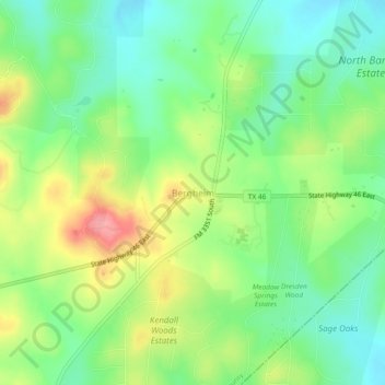
Name: Topografische Karte Bergheim, Höhe, Relief.
Ort: Bergheim, Kendall County, Texas, United States (29.80744 -98.59530 29.84744 -98.55530)
Durchschnittliche Höhe: 419 m
Minimale Höhe: 380 m
Maximale Höhe: 481 m
Andere topografische Karten
Klicken Sie auf eine Karte, um ihre Topografie, ihre Höhe und ihr Relief anzuzeigen.