
Topografische Karte Ahaura River
Interaktive Karte
Klicken Sie auf die Karte, um die Höhe anzuzeigen.
Über diese Karte
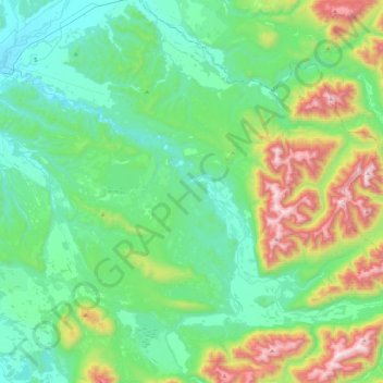
Name: Topografische Karte Ahaura River, Höhe, Relief.
Ort: Ahaura River, Grey District, West Coast, 7843, New Zealand (-42.56351 171.52317 -42.34742 171.97023)
Durchschnittliche Höhe: 386 m
Minimale Höhe: 47 m
Maximale Höhe: 1.459 m
Andere topografische Karten
Klicken Sie auf eine Karte, um ihre Topografie, ihre Höhe und ihr Relief anzuzeigen.
Greymouth
New Zealand > West Coast > Grey District
Greymouth, Grey District, West Coast, 7801, New Zealand
Durchschnittliche Höhe: 40 m
Atarau
New Zealand > West Coast > Grey District
Atarau, Grey District, West Coast, 7843, New Zealand
Durchschnittliche Höhe: 59 m
Taylorville
New Zealand > West Coast > Grey District
Taylorville, Grey District, West Coast, New Zealand
Durchschnittliche Höhe: 125 m
Lake Brunner
New Zealand > West Coast > Grey District > Moana
Lake Brunner, Moana, Grey District, West Coast, New Zealand
Durchschnittliche Höhe: 168 m
Ngahere
New Zealand > West Coast > Grey District > Ngahere
Ngahere, Grey District, West Coast, 7804, New Zealand
Durchschnittliche Höhe: 49 m