Geolokalisieren

Topografische Karte Lapas

Klicken Sie auf die Karte, um die Höhe anzuzeigen.

Über diese Karte
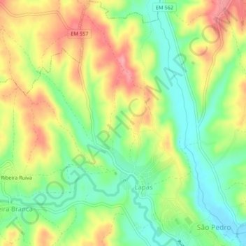
Name: Topografische Karte Lapas, Höhe, Relief.

Ort: Lapas, São Pedro, Lapas e Ribeira Branca, Torres Novas, Santarém, Portugal (39.48595 -8.57328 39.51776 -8.54289)

Durchschnittliche Höhe: 80 m

Minimale Höhe: 32 m

Maximale Höhe: 137 m

Andere topografische Karten

Klicken Sie auf eine Karte, um ihre Topografie, ihre Höhe und ihr Relief anzuzeigen.
Corredoura

Portugal > Santarém > Torres Novas > Assentiz

Durchschnittliche Höhe: 174 m

Casais Martanes

Portugal > Santarém > Torres Novas > Pedrógão

Durchschnittliche Höhe: 131 m

Mata

Portugal > Santarém > Torres Novas > Chancelaria

Durchschnittliche Höhe: 100 m

Caveira

Portugal > Santarém > Torres Novas

Durchschnittliche Höhe: 51 m

Almonda

Portugal > Santarém > Torres Novas > Zibreira

Durchschnittliche Höhe: 120 m

Alcorriol

Portugal > Santarém > Torres Novas

Durchschnittliche Höhe: 113 m

Casal da Pinheira

Portugal > Santarém > Torres Novas

Durchschnittliche Höhe: 99 m

Rendufas da Mata

Portugal > Santarém > Torres Novas

Durchschnittliche Höhe: 106 m

Ribeira Ruiva

Portugal > Santarém > Torres Novas

Durchschnittliche Höhe: 91 m

Barroca

Portugal > Santarém > Torres Novas

Durchschnittliche Höhe: 69 m

Aire

Portugal > Santarém > Torres Novas

Durchschnittliche Höhe: 553 m

Outeiro Grande

Portugal > Santarém > Torres Novas > Assentiz

Durchschnittliche Höhe: 118 m

Videla

Portugal > Santarém > Torres Novas > Zibreira

Durchschnittliche Höhe: 114 m

Villa Romana de Cardilio

Portugal > Santarém > Torres Novas > Caveira

Durchschnittliche Höhe: 38 m

Pousos

Portugal > Santarém > Torres Novas

Durchschnittliche Höhe: 110 m

Aire

Portugal > Santarém > Torres Novas

Durchschnittliche Höhe: 553 m