Geolokalisieren

Topografische Karte Staythorpe CP

Interaktive Karte

Klicken Sie auf die Karte, um die Höhe anzuzeigen.

Über diese Karte

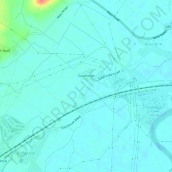
Name: Topografische Karte Staythorpe CP, Höhe, Relief.

Ort: Staythorpe CP, Newark and Sherwood, Nottinghamshire, England, United Kingdom (53.06644 -0.89217 53.08617 -0.85220)

Durchschnittliche Höhe: 16 m

Minimale Höhe: 9 m

Maximale Höhe: 58 m

The land is very low-lying and level, varying little in elevation between 12–14 metres (39–46 ft) throughout.

Wikipedia (CC-BY-SA 3.0)

Andere topografische Karten

Klicken Sie auf eine Karte, um ihre Topografie, ihre Höhe und ihr Relief anzuzeigen.

Newark on Trent

United Kingdom > England > Nottinghamshire > Newark and Sherwood

Newark on Trent, Newark and Sherwood, Nottinghamshire, England, NG24 1EJ, United Kingdom

Durchschnittliche Höhe: 18 m

Sherwood Forest NNR

United Kingdom > England > Nottinghamshire > Newark and Sherwood > Ollerton

Sherwood Forest NNR, Ollerton, Newark and Sherwood, Nottinghamshire, England, NG21 9HN, United Kingdom

Durchschnittliche Höhe: 71 m

Southwell CP

United Kingdom > England > Nottinghamshire > Newark and Sherwood

Southwell CP, Newark and Sherwood, Nottinghamshire, England, United Kingdom

Durchschnittliche Höhe: 47 m

Goverton

United Kingdom > England > Nottinghamshire > Newark and Sherwood > Bleasby

Goverton, Bleasby, Newark and Sherwood, Nottinghamshire, England, NG14 7FN, United Kingdom

Durchschnittliche Höhe: 33 m