
Topografische Karte Dhanbad
Interaktive Karte
Klicken Sie auf die Karte, um die Höhe anzuzeigen.
Über diese Karte
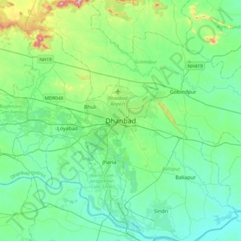
Name: Topografische Karte Dhanbad, Höhe, Relief.
Durchschnittliche Höhe: 212 m
Minimale Höhe: 113 m
Maximale Höhe: 633 m
Dhanbad has an average elevation of 227 m (745 ft). Its geographical length (extending from north to south) is 15 miles (24 km) and the breadth (stretching across east to West) is 10 miles (16 km). It shares its boundaries with West Bengal in the eastern and southern part, Giridih and Dumka in the North and Bokaro District in the west. Dhanbad comes under the Chota Nagpur Plateau.
Andere topografische Karten
Klicken Sie auf eine Karte, um ihre Topografie, ihre Höhe und ihr Relief anzuzeigen.