
Topografische Karte Towson
Interaktive Karte
Klicken Sie auf die Karte, um die Höhe anzuzeigen.
Über diese Karte
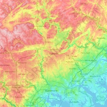
Name: Topografische Karte Towson, Höhe, Relief.
Ort: Towson, Baltimore County, Maryland, 21252, United States (39.24185 -76.76238 39.56185 -76.44238)
Durchschnittliche Höhe: 101 m
Minimale Höhe: -3 m
Maximale Höhe: 225 m
Andere topografische Karten
Klicken Sie auf eine Karte, um ihre Topografie, ihre Höhe und ihr Relief anzuzeigen.
Linden Springs
United States > Maryland > Baltimore County
Linden Springs, Baltimore County, Maryland, 21053, United States
Durchschnittliche Höhe: 253 m
Treetops
United States > Maryland > Baltimore County
Treetops, Baltimore County, Maryland, United States
Durchschnittliche Höhe: 131 m
Upperco
United States > Maryland > Baltimore County
Upperco, Baltimore County, Maryland, 21155, United States
Durchschnittliche Höhe: 218 m
Parkville
United States > Maryland > Baltimore County
Parkville, Baltimore County, Maryland, 21234, United States
Durchschnittliche Höhe: 91 m
Reisterstown
United States > Maryland > Baltimore County > Reisterstown
Reisterstown, Baltimore County, Maryland, 21136, United States
Durchschnittliche Höhe: 199 m
Pikesville
United States > Maryland > Baltimore County > Pikesville
Pikesville, Baltimore County, Maryland, United States
Durchschnittliche Höhe: 135 m
Middle River
United States > Maryland > Baltimore County > Middle River
Middle River, Baltimore County, Maryland, 21220, United States
Durchschnittliche Höhe: 13 m
White Marsh
United States > Maryland > Baltimore County > White Marsh
White Marsh, Baltimore County, Maryland, United States
Durchschnittliche Höhe: 39 m
Rosedale
United States > Maryland > Baltimore County > Rosedale
Rosedale, Baltimore County, Maryland, 21237, United States
Durchschnittliche Höhe: 28 m
Owings Mills
United States > Maryland > Baltimore County > Owings Mills
Owings Mills, Baltimore County, Maryland, 21117, United States
Durchschnittliche Höhe: 173 m
Dundalk
United States > Maryland > Baltimore County > Dundalk
Dundalk, Baltimore County, Maryland, 21222, United States
Durchschnittliche Höhe: 6 m
Jacksonville
United States > Maryland > Baltimore County > Jacksonville
Jacksonville, Baltimore County, Maryland, 21131, United States
Durchschnittliche Höhe: 170 m
Long Green
United States > Maryland > Baltimore County > Towson > Long Green
Long Green, Towson, Baltimore County, Maryland, 21057, United States
Durchschnittliche Höhe: 129 m
Catonsville
United States > Maryland > Baltimore County > Catonsville
Catonsville, Baltimore County, Maryland, United States
Durchschnittliche Höhe: 105 m
Towson
United States > Maryland > Baltimore County > Towson
Towson, Baltimore County, Maryland, United States
Durchschnittliche Höhe: 114 m
Parkville
United States > Maryland > Baltimore County > Parkville
Parkville, Baltimore County, Maryland, 21234, United States
Durchschnittliche Höhe: 111 m
Cockeysville
United States > Maryland > Baltimore County
Cockeysville, Baltimore County, Maryland, 21031, United States
Durchschnittliche Höhe: 131 m