
Spenden
Topografische Karte Madakasira
Klicken Sie auf die Karte, um die Höhe anzuzeigen.
Spenden
Madakasira
Madakasira is located at 13°56′13″N 77°16′10″E / 13.9369°N 77.2694°E / 13.9369; 77.2694. It has an average elevation of 676 metres (2221 ft). The height of the Madakasira hill is 2936 feet from the Sea Level.Formerly Madakasira is called as SIMHAGIRI because hill from one side looks like a sleeping lion. Around Madakasira there are numerous isolated Peaks and Rocky Clusters which are devoid of any vegetation. Madakasira town is cooler compared to the climate of elsewhere in Sri Sathya Sai District, hence aptly known as Ooty of Sri Sathya Sai District.
Spenden
Über diese Karte
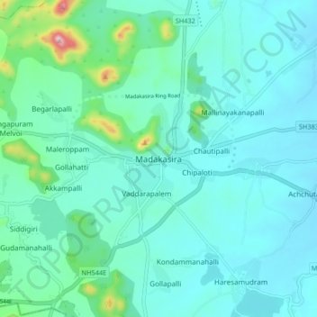
Name: Topografische Karte Madakasira, Höhe, Relief.
Ort: Madakasira, Sri Sathya Sai, Andhra Pradesh, 515300, India (13.90055 77.23259 13.98055 77.31259)
Durchschnittliche Höhe: 684 m
Minimale Höhe: 633 m
Maximale Höhe: 978 m
Spenden