Geolokalisieren
👉 Easily get elevation data in JSON, GeoTIFF and KML formats using Elevation API
Vielen Dank für die Unterstützung dieser Website ❤️
Spenden

Topografische Karte Lladurs

Klicken Sie auf die Karte, um die Höhe anzuzeigen.

👉 Easily get elevation data in JSON, GeoTIFF and KML formats using Elevation API
Vielen Dank für die Unterstützung dieser Website ❤️
Spenden

Über diese Karte

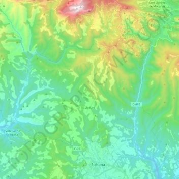
Name: Topografische Karte Lladurs, Höhe, Relief.

Ort: Lladurs, Solsonès, Lleida, Catalonia, 25288, Spain (42.00942 1.36774 42.11179 1.58042)

Durchschnittliche Höhe: 869 m

Minimale Höhe: 521 m

Maximale Höhe: 1.920 m

👉 Easily get elevation data in JSON, GeoTIFF and KML formats using Elevation API
Vielen Dank für die Unterstützung dieser Website ❤️
Spenden

Andere topografische Karten

Klicken Sie auf eine Karte, um ihre Topografie, ihre Höhe und ihr Relief anzuzeigen.

Su

Spain > Catalonia > Solsonès

Su, belongs to the municipality of Riner, in the comarca of Solsonès, vegueria of Comarques Centrals (Catalonia). Su is situated at an elevation of 726 meters above sea level.

Durchschnittliche Höhe: 738 m

Su

Spain > Catalonia > Solsonès

Su, belongs to the municipality of Riner, in the comarca of Solsonès, vegueria of Comarques Centrals (Catalonia). Su is situated at an elevation of 726 meters above sea level.

Durchschnittliche Höhe: 738 m

Canalda

Spain > Catalonia > Solsonès > Odèn

Durchschnittliche Höhe: 1.288 m

la Coma

Spain > Catalonia > Solsonès > la Coma i la Pedra

Durchschnittliche Höhe: 1.308 m

Vielen Dank für die Unterstützung dieser Website ❤️
Spenden