
Topografische Karte Belmont
Interaktive Karte
Klicken Sie auf die Karte, um die Höhe anzuzeigen.
Über diese Karte
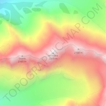
Name: Topografische Karte Belmont, Höhe, Relief.
Ort: Belmont, Westland District, West Coast, New Zealand (-43.56565 170.09786 -43.56555 170.09796)
Durchschnittliche Höhe: 1.623 m
Minimale Höhe: 972 m
Maximale Höhe: 2.199 m
Andere topografische Karten
Klicken Sie auf eine Karte, um ihre Topografie, ihre Höhe und ihr Relief anzuzeigen.
Okuru
New Zealand > West Coast > Westland District
Okuru, Westland District, West Coast, New Zealand
Durchschnittliche Höhe: 3 m
Gillespies Beach
New Zealand > West Coast > Westland District
Gillespies Beach, Westland District, West Coast, New Zealand
Durchschnittliche Höhe: 14 m
Hokitika
New Zealand > West Coast > Westland District
Hokitika, Westland District, West Coast, 7810, New Zealand
Durchschnittliche Höhe: 14 m
Waikowai Stream
New Zealand > West Coast > Westland District
Waikowai Stream, Westland District, West Coast, New Zealand
Durchschnittliche Höhe: 13 m
Hooker Glacier
New Zealand > West Coast > Westland District
Hooker Glacier, Westland District, West Coast, New Zealand
Durchschnittliche Höhe: 1.930 m
Haast
New Zealand > West Coast > Westland District
Haast, Westland District, West Coast, New Zealand
Durchschnittliche Höhe: 15 m
Fox Glacier
New Zealand > West Coast > Westland District
Fox Glacier, Westland District, West Coast, New Zealand
Durchschnittliche Höhe: 1.848 m
Franz Josef
New Zealand > West Coast > Westland District
Franz Josef, Westland District, West Coast, 7856, New Zealand
Durchschnittliche Höhe: 277 m
Mount Tasman
New Zealand > West Coast > Westland District
Mount Tasman, Westland District, West Coast, New Zealand
Durchschnittliche Höhe: 2.798 m