
Spenden
Topografische Karte Enniscoush
Klicken Sie auf die Karte, um die Höhe anzuzeigen.
Spenden
Über diese Karte
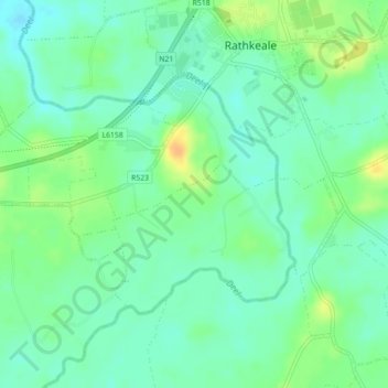
Name: Topografische Karte Enniscoush, Höhe, Relief.
Durchschnittliche Höhe: 38 m
Minimale Höhe: 26 m
Maximale Höhe: 58 m
Spenden
Andere topografische Karten
Klicken Sie auf eine Karte, um ihre Topografie, ihre Höhe und ihr Relief anzuzeigen.
Crecora
Ireland > County Limerick > The Municipal District of Adare — Rathkeale
Durchschnittliche Höhe: 37 m
Bleach Lough
Ireland > County Limerick > The Municipal District of Adare — Rathkeale
Durchschnittliche Höhe: 10 m
Deel
Ireland > County Limerick > The Municipal District of Adare — Rathkeale
Durchschnittliche Höhe: 25 m
Croom
Ireland > County Limerick > The Municipal District of Adare — Rathkeale > Croom
Durchschnittliche Höhe: 34 m
Spenden
Tory Hill
Ireland > County Limerick > The Municipal District of Adare — Rathkeale
Durchschnittliche Höhe: 35 m