
Topografische Karte Motiti Island
Interaktive Karte
Klicken Sie auf die Karte, um die Höhe anzuzeigen.
Über diese Karte
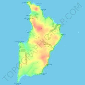
Name: Topografische Karte Motiti Island, Höhe, Relief.
Ort: Motiti Island, Tauranga, Bay of Plenty, New Zealand (-37.64740 176.40678 -37.60209 176.43812)
Durchschnittliche Höhe: 10 m
Minimale Höhe: 0 m
Maximale Höhe: 62 m
Andere topografische Karten
Klicken Sie auf eine Karte, um ihre Topografie, ihre Höhe und ihr Relief anzuzeigen.
Tauranga
New Zealand > Bay of Plenty > Tauranga
Tauranga, Tauranga City, Bay of Plenty, New Zealand
Durchschnittliche Höhe: 10 m
Moturiki Island (Leisure Island)
New Zealand > Bay of Plenty > Tauranga
Moturiki Island (Leisure Island), Tauranga, Bay of Plenty, New Zealand
Durchschnittliche Höhe: 8 m
Wairoa River
New Zealand > Bay of Plenty > Tauranga
Wairoa River, Tauranga, Tauranga City, Bay of Plenty, 3171, New Zealand
Durchschnittliche Höhe: 65 m
Lake Aroarotamahine
New Zealand > Bay of Plenty > Tauranga
Lake Aroarotamahine, Tauranga, Tauranga City, Bay of Plenty, New Zealand
Durchschnittliche Höhe: 82 m
Mayor Island
New Zealand > Bay of Plenty > Tauranga
Mayor Island, Tauranga, Bay of Plenty, New Zealand
Durchschnittliche Höhe: 71 m
Yatton Park
New Zealand > Bay of Plenty > Tauranga
Yatton Park, Begonia Way, Merivale, Tauranga, Tauranga City, Bay of Plenty, 3112, New Zealand
Durchschnittliche Höhe: 19 m