
Topografische Karte Stratton
Interaktive Karte
Klicken Sie auf die Karte, um die Höhe anzuzeigen.
Über diese Karte
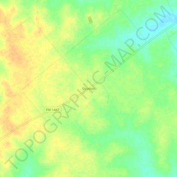
Name: Topografische Karte Stratton, Höhe, Relief.
Ort: Stratton, DeWitt County, Texas, United States (29.13164 -97.17027 29.17164 -97.13027)
Durchschnittliche Höhe: 87 m
Minimale Höhe: 69 m
Maximale Höhe: 100 m
Andere topografische Karten
Klicken Sie auf eine Karte, um ihre Topografie, ihre Höhe und ihr Relief anzuzeigen.
Garfield
United States > Texas > DeWitt County
Garfield, DeWitt County, Texas, United States
Durchschnittliche Höhe: 136 m
Yorktown
United States > Texas > DeWitt County
Yorktown, DeWitt County, Texas, United States
Durchschnittliche Höhe: 90 m
Concrete
United States > Texas > DeWitt County
Concrete, DeWitt County, Texas, United States
Durchschnittliche Höhe: 80 m
Thomaston
United States > Texas > DeWitt County
Thomaston, DeWitt County, Texas, 77989, United States
Durchschnittliche Höhe: 49 m
Cuero
United States > Texas > DeWitt County
Cuero, DeWitt County, Texas, 77954, United States
Durchschnittliche Höhe: 65 m
Cuero
United States > Texas > DeWitt County > Cuero
Cuero, DeWitt County, Texas, 77954, United States
Durchschnittliche Höhe: 61 m