Geolokalisieren

Topografische Karte La Garde

Interaktive Karte

Klicken Sie auf die Karte, um die Höhe anzuzeigen.

Über diese Karte

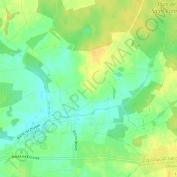
Name: Topografische Karte La Garde, Höhe, Relief.

Ort: La Garde, La Troche, Thenay, Le Controis-en-Sologne, Romorantin-Lanthenay, Loir-et-Cher, Centre-Val de Loire, France métropolitaine, 41400, France (47.39164 1.30711 47.41164 1.32711)

Durchschnittliche Höhe: 106 m

Minimale Höhe: 93 m

Maximale Höhe: 117 m

Andere topografische Karten

Klicken Sie auf eine Karte, um ihre Topografie, ihre Höhe und ihr Relief anzuzeigen.

Contres

France > Centre-Val de Loire > Loir-et-Cher > Le Controis-en-Sologne

Contres, Le Controis-en-Sologne, Romorantin-Lanthenay, Loir-et-Cher, Centre-Val de Loire, France métropolitaine, 41700, France

Durchschnittliche Höhe: 107 m

Peraclos

France > Centre-Val de Loire > Loir-et-Cher > Le Controis-en-Sologne > Les Aunaux

Peraclos, Les Aunaux, Feings, Le Controis-en-Sologne, Romorantin-Lanthenay, Loir-et-Cher, Centre-Val de Loire, France métropolitaine, 41120, France

Durchschnittliche Höhe: 95 m

Le Controis en Sologne

France > Centre-Val de Loire > Loir-et-Cher > Le Controis-en-Sologne

Le Controis en Sologne, Le Controis-en-Sologne, Romorantin-Lanthenay, Loir-et-Cher, Centre-Val de Loire, France métropolitaine, 41700, France

Durchschnittliche Höhe: 104 m

Coulomme

France > Centre-Val de Loire > Loir-et-Cher > Le Controis-en-Sologne > Coulomnes

Coulomme, Coulomnes, Feings, Le Controis-en-Sologne, Romorantin-Lanthenay, Loir-et-Cher, Centre-Val de Loire, France métropolitaine, 41120, France

Durchschnittliche Höhe: 93 m