Geolokalisieren

Topografische Karte Rosyth

Interaktive Karte

Klicken Sie auf die Karte, um die Höhe anzuzeigen.

Über diese Karte

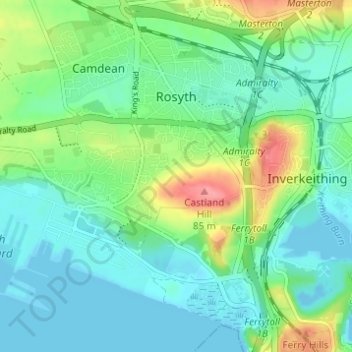
Name: Topografische Karte Rosyth, Höhe, Relief.

Ort: Rosyth, Fife, Scotland, United Kingdom (56.01458 -3.46476 56.04760 -3.40341)

Durchschnittliche Höhe: 23 m

Minimale Höhe: -5 m

Maximale Höhe: 82 m

Andere topografische Karten

Klicken Sie auf eine Karte, um ihre Topografie, ihre Höhe und ihr Relief anzuzeigen.

Auchtermuchty

United Kingdom > Scotland > Fife

Auchtermuchty, Fife, Scotland, KY14 7AP, United Kingdom

Durchschnittliche Höhe: 108 m

Cupar

United Kingdom > Scotland > Fife

Cupar, Fife, Scotland, KY15 4BP, United Kingdom

Durchschnittliche Höhe: 75 m

Auchtertool

United Kingdom > Scotland > Fife

Auchtertool, Fife, Scotland, United Kingdom

Durchschnittliche Höhe: 113 m

Crail

United Kingdom > Scotland > Fife

Crail, Fife, Scotland, KY10 3UG, United Kingdom

Durchschnittliche Höhe: 21 m

Kinghorn

United Kingdom > Scotland > Fife

Kinghorn, Fife, Scotland, United Kingdom

Durchschnittliche Höhe: 30 m

Rankeilour

United Kingdom > Scotland > Fife > Springfield

Rankeilour, Springfield, Fife, Scotland, KY15 5RE, United Kingdom

Durchschnittliche Höhe: 48 m

Dunfermline

United Kingdom > Scotland > Fife

Dunfermline, Fife, Scotland, United Kingdom

Durchschnittliche Höhe: 114 m

Falkland

United Kingdom > Scotland > Fife

Falkland, Fife, Scotland, KY15 7BU, United Kingdom

Durchschnittliche Höhe: 133 m

Leuchars

United Kingdom > Scotland > Fife > Leuchars

Leuchars, Fife, Scotland, KY16 0HH, United Kingdom

Durchschnittliche Höhe: 22 m

Tayport

United Kingdom > Scotland > Fife

Tayport, Fife, Scotland, DD6 9AE, United Kingdom

Durchschnittliche Höhe: 22 m