
Topografische Karte The Falls at Imperial Oaks
Interaktive Karte
Klicken Sie auf die Karte, um die Höhe anzuzeigen.
Über diese Karte
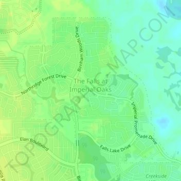
Name: Topografische Karte The Falls at Imperial Oaks, Höhe, Relief.
Durchschnittliche Höhe: 32 m
Minimale Höhe: 23 m
Maximale Höhe: 37 m
Andere topografische Karten
Klicken Sie auf eine Karte, um ihre Topografie, ihre Höhe und ihr Relief anzuzeigen.
The Woodlands
United States > Texas > Montgomery County
The Woodlands, Montgomery County, Texas, United States
Durchschnittliche Höhe: 47 m
Security
United States > Texas > Montgomery County
Security, Montgomery County, Texas, United States
Durchschnittliche Höhe: 53 m
LITTLE LAKE CONROE
United States > Texas > Montgomery County > Conroe
LITTLE LAKE CONROE, Conroe, Montgomery County, Texas, United States
Durchschnittliche Höhe: 77 m
Benders Landing
United States > Texas > Montgomery County
Benders Landing, Montgomery County, Texas, United States
Durchschnittliche Höhe: 29 m
Porter
United States > Texas > Montgomery County
Porter, Montgomery County, Texas, 77365, United States
Durchschnittliche Höhe: 30 m
Alden Bridge
United States > Texas > Montgomery County > The Woodlands
Alden Bridge, The Woodlands, Montgomery County, Texas, 77382, United States
Durchschnittliche Höhe: 55 m
Magnolia
United States > Texas > Montgomery County
Magnolia, Montgomery County, Texas, United States
Durchschnittliche Höhe: 77 m
New Caney
United States > Texas > Montgomery County
New Caney, Montgomery County, Texas, 77357, United States
Durchschnittliche Höhe: 30 m
Lake Egypt
United States > Texas > Montgomery County > Egypt
Lake Egypt, Laurelwoode, Egypt, Montgomery County, Texas, United States
Durchschnittliche Höhe: 61 m
Conroe
United States > Texas > Montgomery County > Conroe > Conroe
Conroe, Montgomery County, Texas, 77301, United States
Durchschnittliche Höhe: 60 m
Panther Creek
United States > Texas > Montgomery County > The Woodlands
Panther Creek, The Woodlands, Montgomery County, Texas, United States
Durchschnittliche Höhe: 47 m
Willis
United States > Texas > Montgomery County
Willis, Montgomery County, Texas, 77305, United States
Durchschnittliche Höhe: 99 m
Conroe
United States > Texas > Montgomery County
Conroe, Montgomery County, Texas, United States
Durchschnittliche Höhe: 62 m
Sterling Ridge
United States > Texas > Montgomery County > The Woodlands
Sterling Ridge, The Woodlands, Montgomery County, Texas, United States
Durchschnittliche Höhe: 55 m