
Topografische Karte Kapuskasing
Interaktive Karte
Klicken Sie auf die Karte, um die Höhe anzuzeigen.
Über diese Karte
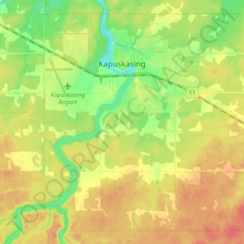
Name: Topografische Karte Kapuskasing, Höhe, Relief.
Durchschnittliche Höhe: 227 m
Minimale Höhe: 202 m
Maximale Höhe: 249 m
Kapuskasing lies in the heart of the Great Clay Belt. The topography of the region is very flat, dotted with numerous small lakes and muskeg bogs. Also in the heart of Canada's boreal forest, the region is drained by rivers running north to James Bay. The district is heavily forested, mostly by thick stands of black spruce that have commercial value as pulpwood.
Andere topografische Karten
Klicken Sie auf eine Karte, um ihre Topografie, ihre Höhe und ihr Relief anzuzeigen.
Moosonee
Canada > Ontario > Cochrane District
Moosonee, Cochrane District, Northeastern Ontario, Ontario, P0L 1Y0, Canada
Durchschnittliche Höhe: 13 m
Heart Lake
Canada > Ontario > Cochrane District > Timmins
Heart Lake, Timmins, Cochrane District, Northeastern Ontario, Ontario, Canada
Durchschnittliche Höhe: 294 m
Shallow River
Canada > Ontario > Cochrane District > Iroquois Falls
Shallow River, Iroquois Falls, Cochrane District, Northeastern Ontario, Ontario, Canada
Durchschnittliche Höhe: 272 m
Wavell
Canada > Ontario > Cochrane District > Black River-Matheson Township
Wavell, Black River-Matheson Township, Cochrane District, Northeastern Ontario, Ontario, Canada
Durchschnittliche Höhe: 304 m
Schumacher
Canada > Ontario > Cochrane District > Timmins
Schumacher, Timmins, Cochrane District, Northeastern Ontario, Ontario, P0N 1G0, Canada
Durchschnittliche Höhe: 306 m
Ramore
Canada > Ontario > Cochrane District
Ramore, Black River-Matheson Township, Cochrane District, Northeastern Ontario, Ontario, Canada
Durchschnittliche Höhe: 289 m
Timmins
Canada > Ontario > Cochrane District
Timmins, Cochrane District, Northeastern Ontario, Ontario, Canada
Durchschnittliche Höhe: 302 m