
Topografische Karte Guilin
Interaktive Karte
Klicken Sie auf die Karte, um die Höhe anzuzeigen.
Über diese Karte
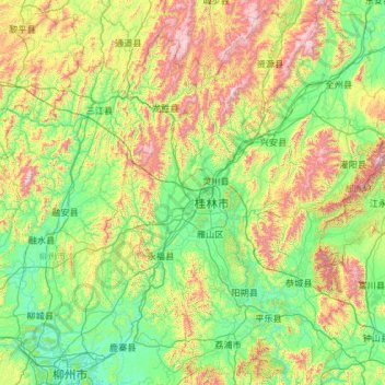
Name: Topografische Karte Guilin, Höhe, Relief.
Ort: Guilin, Guangxi, China (24.26275 109.61164 26.38787 111.48759)
Durchschnittliche Höhe: 477 m
Minimale Höhe: 65 m
Maximale Höhe: 2.046 m
Guilin (Standard Zhuang: Gveilinz; alternatively romanized as Kweilin) is a prefecture-level city in the northeast of China's Guangxi Zhuang Autonomous Region. It is situated on the west bank of the Li River and borders Hunan to the north. Its name means "forest of sweet osmanthus", owing to the large number of fragrant sweet osmanthus trees located in the region. The city has long been renowned for its scenery of karst topography.
Andere topografische Karten
Klicken Sie auf eine Karte, um ihre Topografie, ihre Höhe und ihr Relief anzuzeigen.
Zhongshan
China > Guangxi > Zhongshan County
Zhongshan, Zhongshan County, Hezhou, Guangxi, China
Durchschnittliche Höhe: 246 m
Lingchuan County
Lingchuan County, Guilin, Guangxi, 541203, China
Durchschnittliche Höhe: 431 m
Long'an County
Long'an County, Nanning, Guangxi, China
Durchschnittliche Höhe: 255 m
Guanyang County
Guanyang County, Guilin, Guangxi, 541607, China
Durchschnittliche Höhe: 635 m
Pingnan County
Pingnan County, Chini, Guigang, Guangxi, China
Durchschnittliche Höhe: 36 m
Luocheng Mulao Autonomous County
Luocheng Mulao Autonomous County, Yule, Hechi, Guangxi, China
Durchschnittliche Höhe: 226 m