
Topografische Karte Ligonier
Interaktive Karte
Klicken Sie auf die Karte, um die Höhe anzuzeigen.
Über diese Karte
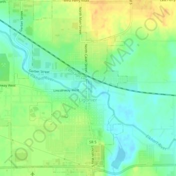
Name: Topografische Karte Ligonier, Höhe, Relief.
Ort: Ligonier, Noble County, Indiana, United States (41.45034 -85.61066 41.48133 -85.57830)
Durchschnittliche Höhe: 277 m
Minimale Höhe: 262 m
Maximale Höhe: 295 m
Andere topografische Karten
Klicken Sie auf eine Karte, um ihre Topografie, ihre Höhe und ihr Relief anzuzeigen.
Chain O'Lakes State Park
United States > Indiana > Noble County
Chain O'Lakes State Park, 9, Noble County, Indiana, United States
Durchschnittliche Höhe: 290 m
Avilla
United States > Indiana > Noble County
Avilla, Noble County, Indiana, United States
Durchschnittliche Höhe: 294 m
Kendallville
United States > Indiana > Noble County
Kendallville, Noble County, Indiana, 46755, United States
Durchschnittliche Höhe: 303 m
Albion
United States > Indiana > Noble County
Albion, Noble County, Indiana, United States
Durchschnittliche Höhe: 285 m
Kendallville
United States > Indiana > Noble County > Kendallville > Kendallville
Kendallville, Noble County, Indiana, 46755, United States
Durchschnittliche Höhe: 304 m
Wolcottville
United States > Indiana > Noble County
Wolcottville, Noble County, Indiana, United States
Durchschnittliche Höhe: 287 m