
Spenden
Topografische Karte Princess Margaret Range
Klicken Sie auf die Karte, um die Höhe anzuzeigen.
Spenden
Über diese Karte
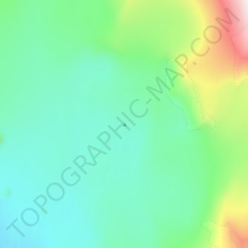
Name: Topografische Karte Princess Margaret Range, Höhe, Relief.
Ort: Princess Margaret Range, Qikiqtaaluk Region, Nunavut, Canada (79.64935 -90.53508 79.64945 -90.53498)
Durchschnittliche Höhe: 1.013 m
Minimale Höhe: 880 m
Maximale Höhe: 1.517 m
Spenden
Andere topografische Karten
Klicken Sie auf eine Karte, um ihre Topografie, ihre Höhe und ihr Relief anzuzeigen.
Arctic Bay
Canada > Nunavut > Qikiqtaaluk Region
Arctic Bay experiences a tundra climate (Köppen: ET) like most northern Canadian territories at low elevations, with long, very cold winters and short, cool to cold summers. July is the only month with an average low temperature above freezing. Its climate does not differ from the more severe subarctic…
Durchschnittliche Höhe: 160 m
Spenden
Spenden
Spenden
Spenden
Arctic Bay
Canada > Nunavut > Qikiqtaaluk Region
Arctic Bay experiences a tundra climate (Köppen: ET) like most northern Canadian territories at low elevations, with long, very cold winters and short, cool to cold summers. July is the only month with an average low temperature above freezing. Its climate does not differ from the more severe subarctic…
Durchschnittliche Höhe: 137 m
Spenden
Spenden
Spenden
Spenden
Arctic Bay
Canada > Nunavut > Qikiqtaaluk Region
Arctic Bay experiences a tundra climate (Köppen: ET) like most northern Canadian territories at low elevations, with long, very cold winters and short, cool to cold summers. July is the only month with an average low temperature above freezing. Its climate does not differ from the more severe subarctic…
Durchschnittliche Höhe: 137 m
Spenden
Spenden
Spenden