
Spenden
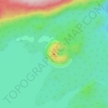
Topografische Karte Fire Mountain
Klicken Sie auf die Karte, um die Höhe anzuzeigen.
Spenden
Fire Mountain
Kostal Cone, also called Kostal Volcano and Fire Mountain, is a young cinder cone in Wells Gray Provincial Park in east-central British Columbia, Canada. It rises from the northeast shore of Kostal Lake in the Cariboo Mountains. With an elevation of 1,440 m (4,724 ft), Kostal Cone is one of the lowest volcanoes in the Wells Gray-Clearwater volcanic field.
Spenden
Über diese Karte
Name: Topografische Karte Fire Mountain, Höhe, Relief.
Durchschnittliche Höhe: 1.316 m
Minimale Höhe: 1.231 m
Maximale Höhe: 1.545 m
Spenden
Andere topografische Karten
Klicken Sie auf eine Karte, um ihre Topografie, ihre Höhe und ihr Relief anzuzeigen.
Strait Lake
Canada > British Columbia > Thompson-Nicola Regional District > Area A (Wells Gray Country)
Durchschnittliche Höhe: 1.531 m
Murtle Lake
Canada > British Columbia > Thompson-Nicola Regional District > Area A (Wells Gray Country)
Durchschnittliche Höhe: 1.470 m