Geolokalisieren
👉 Easily get elevation data in JSON, GeoTIFF and KML formats using Elevation API
Vielen Dank für die Unterstützung dieser Website ❤️
Spenden

Topografische Karte Lugnaquilla

Klicken Sie auf die Karte, um die Höhe anzuzeigen.

👉 Easily get elevation data in JSON, GeoTIFF and KML formats using Elevation API
Vielen Dank für die Unterstützung dieser Website ❤️
Spenden

Lugnaquilla

Lugnaquilla is the 432nd-highest and 21st most prominent mountain in Britain and Ireland, on the Simms classification. It is regarded by the Scottish Mountaineering Club (SMC) as one of 34 Furths, which is a mountain above 3,000 ft (914 m) in elevation, and meets the other SMC criteria for a Munro (e.g. "sufficient separation"), but which is outside of (or furth) Scotland; which is why Lugnaquilla is referred to as one of the 13 Irish Munros.

Wikipedia (CC-BY-SA 3.0)

👉 Easily get elevation data in JSON, GeoTIFF and KML formats using Elevation API
Vielen Dank für die Unterstützung dieser Website ❤️
Spenden

Über diese Karte

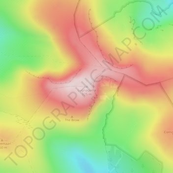
Name: Topografische Karte Lugnaquilla, Höhe, Relief.

Ort: Lugnaquilla, The Municipal District of Baltinglass, County Wicklow, Leinster, Ireland (52.96710 -6.46468 52.96720 -6.46458)

Durchschnittliche Höhe: 696 m

Minimale Höhe: 435 m

Maximale Höhe: 927 m

👉 Easily get elevation data in JSON, GeoTIFF and KML formats using Elevation API
Vielen Dank für die Unterstützung dieser Website ❤️
Spenden

Andere topografische Karten

Klicken Sie auf eine Karte, um ihre Topografie, ihre Höhe und ihr Relief anzuzeigen.

Blessington

Ireland > County Wicklow

Durchschnittliche Höhe: 204 m

Blessington

Ireland > County Wicklow

Durchschnittliche Höhe: 204 m

Bray

Ireland > County Wicklow

Durchschnittliche Höhe: 42 m

Rathdrum

Ireland > County Wicklow

Durchschnittliche Höhe: 136 m

Vielen Dank für die Unterstützung dieser Website ❤️
Spenden

Laragh

Ireland > County Wicklow

Durchschnittliche Höhe: 215 m

Roundwood

Ireland > County Wicklow

Durchschnittliche Höhe: 242 m

Carrick

Ireland > County Wicklow

Durchschnittliche Höhe: 163 m

Lower Lough Bray

Ireland > County Wicklow

Durchschnittliche Höhe: 455 m

Vielen Dank für die Unterstützung dieser Website ❤️
Spenden

Wicklow Mountains National Park

Ireland > County Wicklow

Durchschnittliche Höhe: 322 m

Ashford

Ireland > County Wicklow

Durchschnittliche Höhe: 49 m

Toberpatrick

Ireland > County Wicklow

Durchschnittliche Höhe: 157 m

Johnstown Lower

Ireland > County Wicklow

Durchschnittliche Höhe: 64 m

Vielen Dank für die Unterstützung dieser Website ❤️
Spenden

Curtlestown Upper

Ireland > County Wicklow

Durchschnittliche Höhe: 343 m

Avoca

Ireland > County Wicklow

Durchschnittliche Höhe: 117 m

Blessington

Ireland > County Wicklow

Durchschnittliche Höhe: 204 m

Knockananna

Ireland > County Wicklow

Durchschnittliche Höhe: 189 m

Vielen Dank für die Unterstützung dieser Website ❤️
Spenden

Sally Gap

Ireland > County Wicklow

Durchschnittliche Höhe: 512 m

Carnew

Ireland > County Wicklow

Durchschnittliche Höhe: 94 m

Baltinglass

Ireland > County Wicklow

A nineteenth-century explanation is found in Samuel Lewis' A Topographical Dictionary of Ireland, where he says that the name, "according to most antiquaries," comes from Baal-Tin-Glas, meaning the "pure fire of Baal," and that this suggests that the area was a centre for "druidical worship".

Durchschnittliche Höhe: 163 m

Ennereilly

Ireland > County Wicklow

Durchschnittliche Höhe: 10 m

Vielen Dank für die Unterstützung dieser Website ❤️
Spenden

Avondale

Ireland > County Wicklow

Durchschnittliche Höhe: 117 m

Kilpedder

Ireland > County Wicklow

Durchschnittliche Höhe: 99 m

Arklow

Ireland > County Wicklow

Durchschnittliche Höhe: 14 m

Tomriland

Ireland > County Wicklow

Durchschnittliche Höhe: 204 m

Vielen Dank für die Unterstützung dieser Website ❤️
Spenden

Kindlestown Lower

Ireland > County Wicklow

Durchschnittliche Höhe: 58 m

Kilquade

Ireland > County Wicklow

Durchschnittliche Höhe: 61 m

Vielen Dank für die Unterstützung dieser Website ❤️
Spenden

Roundwood

Ireland > County Wicklow

Durchschnittliche Höhe: 227 m

Kilcoole

Ireland > County Wicklow

Durchschnittliche Höhe: 29 m

Glencree

Ireland > County Wicklow

Durchschnittliche Höhe: 358 m

Tinahely

Ireland > County Wicklow

Durchschnittliche Höhe: 128 m

Vielen Dank für die Unterstützung dieser Website ❤️
Spenden

Lugduff

Ireland > County Wicklow

Durchschnittliche Höhe: 111 m

Kilruddery Deerpark

Ireland > County Wicklow

Durchschnittliche Höhe: 132 m

Togher Beg

Ireland > County Wicklow

Durchschnittliche Höhe: 239 m

Knocksink

Ireland > County Wicklow

Durchschnittliche Höhe: 122 m

Vielen Dank für die Unterstützung dieser Website ❤️
Spenden

Shankill

Ireland > County Wicklow

Durchschnittliche Höhe: 438 m

Castlekevin

Ireland > County Wicklow

Durchschnittliche Höhe: 214 m

Newcastle

Ireland > County Wicklow

Durchschnittliche Höhe: 28 m

Curtlestown Lower

Ireland > County Wicklow

Durchschnittliche Höhe: 241 m

Vielen Dank für die Unterstützung dieser Website ❤️
Spenden

The Rocks at Priestnewtown

Ireland > County Wicklow

Durchschnittliche Höhe: 44 m

Aughrim

Ireland > County Wicklow

Durchschnittliche Höhe: 123 m

Burgage

Ireland > County Wicklow

Durchschnittliche Höhe: 211 m

Stagonil Parish

Ireland > County Wicklow

Durchschnittliche Höhe: 365 m

Vielen Dank für die Unterstützung dieser Website ❤️
Spenden

Enniskerry

Ireland > County Wicklow

Durchschnittliche Höhe: 111 m

Cleevaun Lough

Ireland > County Wicklow

Durchschnittliche Höhe: 641 m

Bollarney Murragh

Ireland > County Wicklow

Durchschnittliche Höhe: 9 m

Tomnafinnoge Wood

Ireland > County Wicklow

Durchschnittliche Höhe: 106 m

Vielen Dank für die Unterstützung dieser Website ❤️
Spenden

Newtown Mount Kennedy

Ireland > County Wicklow

Durchschnittliche Höhe: 102 m

Upper Lough Bray

Ireland > County Wicklow

Durchschnittliche Höhe: 496 m

Ballinaclogh

Ireland > County Wicklow

Durchschnittliche Höhe: 108 m

Ballinacor East

Ireland > County Wicklow

Durchschnittliche Höhe: 65 m

Vielen Dank für die Unterstützung dieser Website ❤️
Spenden

Turlough Hill Reservoir

Ireland > County Wicklow

Durchschnittliche Höhe: 556 m

Kilbaylet Lower

Ireland > County Wicklow

Durchschnittliche Höhe: 257 m

Knocksink Wood

Ireland > County Wicklow

Durchschnittliche Höhe: 175 m

Tulfarris

Ireland > County Wicklow

Durchschnittliche Höhe: 196 m

Vielen Dank für die Unterstützung dieser Website ❤️
Spenden

Deerpark

Ireland > County Wicklow

Durchschnittliche Höhe: 313 m

Wicklow

Ireland > County Wicklow

Durchschnittliche Höhe: 58 m

Kilcarra West

Ireland > County Wicklow

Durchschnittliche Höhe: 98 m

Tonygarrow

Ireland > County Wicklow

Durchschnittliche Höhe: 350 m

Vielen Dank für die Unterstützung dieser Website ❤️
Spenden

Aghowle

Ireland > County Wicklow

Durchschnittliche Höhe: 154 m

Aghavannagh

Ireland > County Wicklow > Ballygobban Bridge

Durchschnittliche Höhe: 266 m

Arklow

Ireland > County Wicklow

Durchschnittliche Höhe: 16 m

Ballycumber South

Ireland > County Wicklow

Durchschnittliche Höhe: 271 m

Vielen Dank für die Unterstützung dieser Website ❤️
Spenden

Donard

Ireland > County Wicklow

Durchschnittliche Höhe: 212 m

Ballylusk

Ireland > County Wicklow

Durchschnittliche Höhe: 249 m

Dunlavin

Ireland > County Wicklow

Durchschnittliche Höhe: 173 m

Ballinacooley

Ireland > County Wicklow

Durchschnittliche Höhe: 110 m

Vielen Dank für die Unterstützung dieser Website ❤️
Spenden

Newtown

Ireland > County Wicklow

Durchschnittliche Höhe: 104 m

Lough Dan

Ireland > County Wicklow

Durchschnittliche Höhe: 309 m

Lough Tay

Ireland > County Wicklow

Durchschnittliche Höhe: 395 m

Brittas

Ireland > County Wicklow

Durchschnittliche Höhe: 252 m

Vielen Dank für die Unterstützung dieser Website ❤️
Spenden

Springfarm

Ireland > County Wicklow

Durchschnittliche Höhe: 130 m

Newry

Ireland > County Wicklow

Durchschnittliche Höhe: 134 m

Vielen Dank für die Unterstützung dieser Website ❤️
Spenden

Tiknock

Ireland > County Wicklow

Durchschnittliche Höhe: 15 m

Rathmichael (Bray) ED

Ireland > County Wicklow

Durchschnittliche Höhe: 36 m

Glendalough Round Tower

Ireland > County Wicklow

Durchschnittliche Höhe: 265 m

Dunbur Head

Ireland > County Wicklow

Durchschnittliche Höhe: 26 m

Vielen Dank für die Unterstützung dieser Website ❤️
Spenden

Garrymore Lower

Ireland > County Wicklow

Durchschnittliche Höhe: 139 m

Tigroney West

Ireland > County Wicklow

Durchschnittliche Höhe: 121 m

Connary Lower

Ireland > County Wicklow

Durchschnittliche Höhe: 118 m

Milltown North

Ireland > County Wicklow

Durchschnittliche Höhe: 35 m

Vielen Dank für die Unterstützung dieser Website ❤️
Spenden

Ballymerrigan

Ireland > County Wicklow

Durchschnittliche Höhe: 65 m

Slate

Ireland > County Wicklow

Durchschnittliche Höhe: 48 m

Newtown

Ireland > County Wicklow

Durchschnittliche Höhe: 68 m

Powerscourt

Ireland > County Wicklow

Durchschnittliche Höhe: 365 m

Vielen Dank für die Unterstützung dieser Website ❤️
Spenden

Ballinteskin

Ireland > County Wicklow

Durchschnittliche Höhe: 255 m

Rath

Ireland > County Wicklow

Durchschnittliche Höhe: 96 m

Rathgall Hillfort

Ireland > County Wicklow

Durchschnittliche Höhe: 101 m

Dargle

Ireland > County Wicklow

Durchschnittliche Höhe: 241 m

Vielen Dank für die Unterstützung dieser Website ❤️
Spenden

Ballyclogh North

Ireland > County Wicklow

Durchschnittliche Höhe: 50 m

Knockrath

Ireland > County Wicklow

Durchschnittliche Höhe: 299 m

Mountlusk

Ireland > County Wicklow

Durchschnittliche Höhe: 124 m

Cooladoyle

Ireland > County Wicklow

Durchschnittliche Höhe: 164 m

Vielen Dank für die Unterstützung dieser Website ❤️
Spenden

Dunran Hill

Ireland > County Wicklow

Durchschnittliche Höhe: 185 m

Ballinastraw

Ireland > County Wicklow

Durchschnittliche Höhe: 132 m

Coolagad

Ireland > County Wicklow

Durchschnittliche Höhe: 103 m

Sheilstown

Ireland > County Wicklow

Durchschnittliche Höhe: 336 m

Vielen Dank für die Unterstützung dieser Website ❤️
Spenden