
Topografische Karte Hanover Circle
Interaktive Karte
Klicken Sie auf die Karte, um die Höhe anzuzeigen.
Über diese Karte
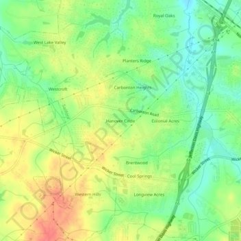
Name: Topografische Karte Hanover Circle, Höhe, Relief.
Durchschnittliche Höhe: 108 m
Minimale Höhe: 79 m
Maximale Höhe: 142 m
Andere topografische Karten
Klicken Sie auf eine Karte, um ihre Topografie, ihre Höhe und ihr Relief anzuzeigen.
Carbonton Heights
United States > North Carolina > Lee County > Sanford
Carbonton Heights, Sanford, Lee County, North Carolina, 27339, United States
Durchschnittliche Höhe: 105 m
Sunset Terrace
United States > North Carolina > Lee County > Sanford
Sunset Terrace, Sanford, Lee County, North Carolina, 27339, United States
Durchschnittliche Höhe: 114 m
Colonial Acres
United States > North Carolina > Lee County > Sanford
Colonial Acres, Sanford, Lee County, North Carolina, 27339, United States
Durchschnittliche Höhe: 106 m
Brookwood
United States > North Carolina > Lee County > Sanford
Brookwood, Sanford, Lee County, North Carolina, 27339, United States
Durchschnittliche Höhe: 105 m
Cool Springs Estates
United States > North Carolina > Lee County > Sanford > Cool Springs Estates
Cool Springs Estates, Sanford, Lee County, North Carolina, 27330, United States
Durchschnittliche Höhe: 98 m
Forest Hills
United States > North Carolina > Lee County > Sanford > Forest Hills
Forest Hills, Sanford, Lee County, North Carolina, 27330, United States
Durchschnittliche Höhe: 98 m
McCracken Heights
United States > North Carolina > Lee County > Sanford
McCracken Heights, Sanford, Lee County, North Carolina, 27330, United States
Durchschnittliche Höhe: 103 m
Berkley Place
United States > North Carolina > Lee County > Sanford > Berkley Place
Berkley Place, Sanford, Lee County, North Carolina, 27339, United States
Durchschnittliche Höhe: 116 m