Topografische Karte Español
Interaktive Karte
Klicken Sie auf die Karte, um die Höhe anzuzeigen.
Über diese Karte
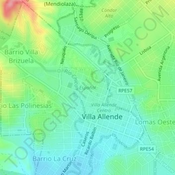
Name: Topografische Karte Español, Höhe, Relief.
Durchschnittliche Höhe: 523 m
Minimale Höhe: 491 m
Maximale Höhe: 596 m

Klicken Sie auf die Karte, um die Höhe anzuzeigen.
Name: Topografische Karte Español, Höhe, Relief.
Durchschnittliche Höhe: 523 m
Minimale Höhe: 491 m
Maximale Höhe: 596 m