
Topografische Karte Fort Saskachewan
Interaktive Karte
Klicken Sie auf die Karte, um die Höhe anzuzeigen.
Über diese Karte
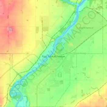
Name: Topografische Karte Fort Saskachewan, Höhe, Relief.
Ort: Fort Saskachewan, Division No. 11, Alberta, Canada (53.65751 -113.29427 53.77426 -113.12414)
Durchschnittliche Höhe: 637 m
Minimale Höhe: 595 m
Maximale Höhe: 700 m
Andere topografische Karten
Klicken Sie auf eine Karte, um ihre Topografie, ihre Höhe und ihr Relief anzuzeigen.
Sherwood Park
Canada > Alberta > Division No. 11
Sherwood Park, Division No. 11, Alberta, Canada
Durchschnittliche Höhe: 691 m
City of Wetaskiwin
Canada > Alberta > Division No. 11
City of Wetaskiwin, Division No. 11, Alberta, Canada
Durchschnittliche Höhe: 760 m
City of Leduc
Canada > Alberta > Division No. 11
City of Leduc, Division No. 11, Alberta, Canada
Durchschnittliche Höhe: 727 m
Chappelle
Canada > Alberta > Division No. 11
Chappelle, Heritage Valley, Division No. 11, Alberta, Canada
Durchschnittliche Höhe: 695 m
Nisku
Canada > Alberta > Division No. 11
Nisku, Division No. 11, Alberta, T9E 0W8, Canada
Durchschnittliche Höhe: 714 m
City of Spruce Grove
Canada > Alberta > Division No. 11
City of Spruce Grove, Division No. 11, Alberta, Canada
Durchschnittliche Höhe: 699 m