
Topografische Karte Biljurashi
Interaktive Karte
Klicken Sie auf die Karte, um die Höhe anzuzeigen.
Über diese Karte
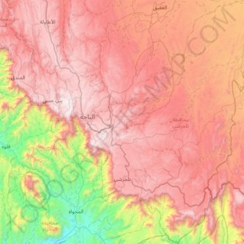
Name: Topografische Karte Biljurashi, Höhe, Relief.
Ort: Biljurashi, Al-Bahah Province, Saudi Arabia (19.69809 41.50283 20.29958 41.97897)
Durchschnittliche Höhe: 1.528 m
Minimale Höhe: 268 m
Maximale Höhe: 2.563 m
Baljurashi (Arabic: بَـلْـجُـرَشِي) or Biljurashi (Arabic: بِـلْـجُـرَشِي) is a city in Al Bahah Region, south-western Saudi Arabia. It is located at around 19°51′40″N 41°33′40″E / 19.8612090°N 41.5609769°E / 19.8612090; 41.5609769 in the elevation of cca 2,000 metres (6,600 feet). It was the capital of the region which includes the tribes of Ghamid and Zahran. It is a medium-sized city in Al Bahah Region. The temperature usually varies between 2 °C (36 °F) in winter and 30 °C (86 °F) in summer. The best time for a visit is from mid-August till the end of September. Most of the native people of Baljurashi live outside it; however, a great number of them spend their summer vacations in the city, which explains the massive increase in population number during summer.
Andere topografische Karten
Klicken Sie auf eine Karte, um ihre Topografie, ihre Höhe und ihr Relief anzuzeigen.
Al Hajrah
Saudi Arabia > Al-Bahah Province
Al Hajrah, Al-Bahah Province, Saudi Arabia
Durchschnittliche Höhe: 481 m