
Topografische Karte Davidson Lake
Interaktive Karte
Klicken Sie auf die Karte, um die Höhe anzuzeigen.
Über diese Karte
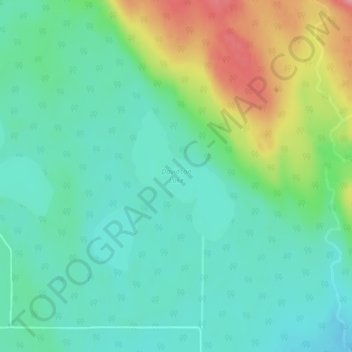
Name: Topografische Karte Davidson Lake, Höhe, Relief.
Durchschnittliche Höhe: 292 m
Minimale Höhe: 259 m
Maximale Höhe: 369 m
Andere topografische Karten
Klicken Sie auf eine Karte, um ihre Topografie, ihre Höhe und ihr Relief anzuzeigen.
Stoney Creek
Canada > Ontario > Thunder Bay District > Unorganized Thunder Bay District
Stoney Creek, Unorganized Thunder Bay District, Thunder Bay District, Northwestern Ontario, Ontario, Canada
Durchschnittliche Höhe: 367 m
Ombabika River
Canada > Ontario > Thunder Bay District > Unorganized Thunder Bay District
Ombabika River, Unorganized Thunder Bay District, Thunder Bay District, Northwestern Ontario, Ontario, Canada
Durchschnittliche Höhe: 311 m
Ara Lake
Canada > Ontario > Thunder Bay District > Unorganized Thunder Bay District
Ara Lake, Unorganized Thunder Bay District, Thunder Bay District, Northwestern Ontario, Ontario, Canada
Durchschnittliche Höhe: 308 m
Ara Island
Canada > Ontario > Thunder Bay District > Unorganized Thunder Bay District
Ara Island, Unorganized Thunder Bay District, Thunder Bay District, Northwestern Ontario, Ontario, Canada
Durchschnittliche Höhe: 305 m
Mowe Lake
Canada > Ontario > Thunder Bay District > Unorganized Thunder Bay District
Mowe Lake, Unorganized Thunder Bay District, Thunder Bay District, Northwestern Ontario, Ontario, Canada
Durchschnittliche Höhe: 463 m
Pringle
Canada > Ontario > Thunder Bay District > Unorganized Thunder Bay District
Pringle, Unorganized Thunder Bay District, Thunder Bay District, Northwestern Ontario, Ontario, Canada
Durchschnittliche Höhe: 289 m