
Topografische Karte Tabanan
Interaktive Karte
Klicken Sie auf die Karte, um die Höhe anzuzeigen.
Über diese Karte
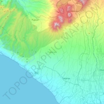
Name: Topografische Karte Tabanan, Höhe, Relief.
Ort: Tabanan, Bali, Indonesia (-8.63601 114.91527 -8.24317 115.21733)
Durchschnittliche Höhe: 450 m
Minimale Höhe: 0 m
Maximale Höhe: 2.235 m
Jatiluwih village in Penebel District, north of Tabanan, has paddy fields following the contours of terraced land against the background of spellbinding Mount Batukaru and Mount Agung use traditional Balinese irrigation known as subak, Bali's community-based water control management system. Lies at an altitude of 700 meters, the cool atmosphere of more original beautiful Jatiluwih is better than the most well-known Tegallalang which has plenty of cafes and souvenir shops. Two routes to Jatiluwih are Denpasar>Kediri>Tabanan>Penebel>Jatiluwih or Denpasar>Mengwi>Baturiti>Jatiluwih. Jatiluwih is one of the five rice terraces that describe the "Subak" water management system which has gain acknowledgment from UNESCO as part of the world's cultural heritage.
Andere topografische Karten
Klicken Sie auf eine Karte, um ihre Topografie, ihre Höhe und ihr Relief anzuzeigen.
Pulau Bali
Pulau Bali, Bali, Lesser Sunda Islands, Indonesia
Durchschnittliche Höhe: 122 m
Candidasa
Indonesia > Bali > Karangasem
Candidasa, Kecamatan Karangasem, Karangasem, Bali, 80851, Indonesia
Durchschnittliche Höhe: 45 m
Kubutambahan
Kubutambahan, Buleleng, Bali, Lesser Sunda Islands, 81172, Indonesia
Durchschnittliche Höhe: 33 m
Semarapura Kelod
Indonesia > Bali > Semarapura Kelod
Semarapura Kelod, Bali, Indonesia
Durchschnittliche Höhe: 80 m
Dauh Puri Kangin
Indonesia > Bali > Denpasar > Dauh Puri Kangin
Dauh Puri Kangin, Denpasar Barat, Denpasar, Bali, 80232, Indonesia
Durchschnittliche Höhe: 26 m