Geolokalisieren

Topografische Karte Pamutan

Interaktive Karte

Klicken Sie auf die Karte, um die Höhe anzuzeigen.

Über diese Karte

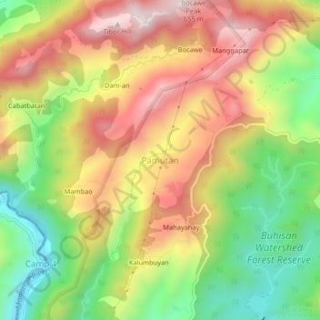
Name: Topografische Karte Pamutan, Höhe, Relief.

Ort: Pamutan, Cebu City, Central Visayas, Philippines (10.31345 123.81548 10.35345 123.85548)

Durchschnittliche Höhe: 356 m

Minimale Höhe: 58 m

Maximale Höhe: 654 m

Andere topografische Karten

Klicken Sie auf eine Karte, um ihre Topografie, ihre Höhe und ihr Relief anzuzeigen.

Pamutan Grassland

Philippines > Cebu City > Pamutan > Mahayahay

Pamutan Grassland, Mahayahay, Pamutan, Cebu City, Central Visayas, Philippines

Durchschnittliche Höhe: 374 m

Sirao Peak

Philippines > Cebu City

Sirao Peak, Cebu City, Central Visayas, Philippines

Durchschnittliche Höhe: 493 m

Pung-ol Peak

Philippines > Cebu City

Pung-ol Peak, Cebu City, Central Visayas, Philippines

Durchschnittliche Höhe: 496 m

Bocawe

Philippines > Cebu City > Bocawe

Bocawe, Cebu City, Central Visayas, Philippines

Durchschnittliche Höhe: 407 m

Bulacao Pardo

Philippines > Cebu City > Bulacao Pardo

Bulacao Pardo, Cebu City, Central Visayas, 6045, Philippines

Durchschnittliche Höhe: 69 m

Mountain View

Philippines > Cebu City > Malubog > Tiguib

Mountain View, Cebu Tops Road, Tiguib, Malubog, Cebu City, Central Visayas, Philippines

Durchschnittliche Höhe: 420 m

Banilad Streetscape

Philippines > Cebu City

Banilad Streetscape, Cebu City, Central Visayas, 6666, Philippines

Durchschnittliche Höhe: 68 m

Piazza Elesia

Philippines > Cebu City > Piazza Elesia

Piazza Elesia, Cebu City, Central Visayas, 653, Philippines

Durchschnittliche Höhe: 69 m