
Spenden
Topografische Karte Aleu
Klicken Sie auf die Karte, um die Höhe anzuzeigen.
Spenden
Aleu
Aleu is located some 10 km south-east of Saint-Girons and 30 km west by south-west of Foix. It can be accessed by the D618 road coming from the west and following the northern border of the commune continuing to Biert in the east. The only access to the village by vehicle is by a small mountain road branching from the D618 at Castet d'Aleu. There is a small unsealed airstrip north-east of the village at approx 1000m altitude. The commune is very rugged with extensive forests. Apart from the village, there are numerous hamlets: Castet d'Aleu, Galas d'en Bas and Galas d'en Haut, La Trappe, La Bordasse, Biech, Pinsou, La Rouere and Fontale.
Spenden
Über diese Karte
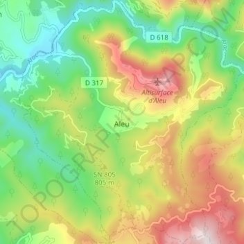
Name: Topografische Karte Aleu, Höhe, Relief.
Durchschnittliche Höhe: 746 m
Minimale Höhe: 491 m
Maximale Höhe: 1.112 m
Spenden
Andere topografische Karten
Klicken Sie auf eine Karte, um ihre Topografie, ihre Höhe und ihr Relief anzuzeigen.
Spenden
Spenden
Mont Valier
France > Occitania > Ariège > Seix
On August 18, 2023, French general Jean-Louis Georgelin fell to his death while hiking on Mont Valier, at an altitude of 2,650 metres (8,690 ft).
Durchschnittliche Höhe: 2.217 m
Spenden
Spenden
Spenden