
Vielen Dank für die Unterstützung dieser Website ❤️
Spenden
Spenden
Topografische Karte Brañaverniz
Klicken Sie auf die Karte, um die Höhe anzuzeigen.
Vielen Dank für die Unterstützung dieser Website ❤️
Spenden
Spenden
Über diese Karte
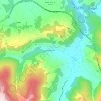
Name: Topografische Karte Brañaverniz, Höhe, Relief.
Ort: Brañaverniz, Villaviciosa, Asturias, 33294, España (43.47277 -5.57669 43.51277 -5.53669)
Durchschnittliche Höhe: 209 m
Minimale Höhe: 44 m
Maximale Höhe: 531 m
Vielen Dank für die Unterstützung dieser Website ❤️
Spenden
Spenden
Andere topografische Karten
Klicken Sie auf eine Karte, um ihre Topografie, ihre Höhe und ihr Relief anzuzeigen.
Selorio
España > Asturias > Villaviciosa
La aldea de Selorio se sitúa en la zona central del término parroquial a una altitud de 25 metros, distando 9 km de la capital municipal. Es de creación moderna, por agrupación de los núcleos de La Ariella, La Barquera, La Calle, La Chispa, Misiego, El Olivar, El Pandal, La Piniella, Rodiles y Terienzo.…
Durchschnittliche Höhe: 77 m
Vielen Dank für die Unterstützung dieser Website ❤️
Spenden
Spenden