
Topografische Karte Morborne
Klicken Sie auf die Karte, um die Höhe anzuzeigen.
Über diese Karte
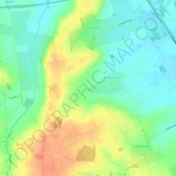
Name: Topografische Karte Morborne, Höhe, Relief.
Durchschnittliche Höhe: 39 m
Minimale Höhe: 20 m
Maximale Höhe: 65 m
Andere topografische Karten
Klicken Sie auf eine Karte, um ihre Topografie, ihre Höhe und ihr Relief anzuzeigen.
Green End
United Kingdom > England > Cambridgeshire > Huntingdonshire > Great Stukeley
Durchschnittliche Höhe: 32 m
Hinchingbrooke Country Park
United Kingdom > England > Cambridgeshire > Huntingdonshire > Huntingdon > Brampton
Durchschnittliche Höhe: 16 m
Pidley
United Kingdom > England > Cambridgeshire > Huntingdonshire > Pidley
Durchschnittliche Höhe: 20 m
Huntingdon Castle
United Kingdom > England > Cambridgeshire > Huntingdonshire > Huntingdon > Hartford
Durchschnittliche Höhe: 14 m
Washingley
United Kingdom > England > Cambridgeshire > Huntingdonshire > Folksworth
Durchschnittliche Höhe: 48 m
Holywell
United Kingdom > England > Cambridgeshire > Huntingdonshire > Holywell
Durchschnittliche Höhe: 7 m
Colne
United Kingdom > England > Cambridgeshire > Huntingdonshire > Colne
Durchschnittliche Höhe: 11 m
Hartford Marina
United Kingdom > England > Cambridgeshire > Huntingdonshire > Wyton
Durchschnittliche Höhe: 14 m
Great Stukeley
United Kingdom > England > Cambridgeshire > Huntingdonshire
Durchschnittliche Höhe: 32 m
Leighton Bromswold
United Kingdom > England > Cambridgeshire > Huntingdonshire
Durchschnittliche Höhe: 49 m
Keyston
United Kingdom > England > Cambridgeshire > Huntingdonshire > Keyston
Durchschnittliche Höhe: 62 m
Mill Pool
United Kingdom > England > Cambridgeshire > Huntingdonshire > Huntingdon
Durchschnittliche Höhe: 14 m