
Vielen Dank für die Unterstützung dieser Website ❤️
Spenden
Spenden
Topografische Karte Hinnom
Klicken Sie auf die Karte, um die Höhe anzuzeigen.
Vielen Dank für die Unterstützung dieser Website ❤️
Spenden
Spenden
Über diese Karte
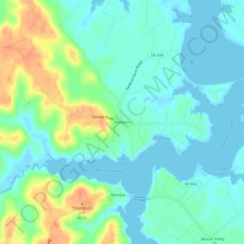
Name: Topografische Karte Hinnom, Höhe, Relief.
Ort: Hinnom, Westmoreland County, Virginia, 22520, United States (38.09041 -76.75690 38.13041 -76.71690)
Durchschnittliche Höhe: 13 m
Minimale Höhe: -2 m
Maximale Höhe: 46 m
Vielen Dank für die Unterstützung dieser Website ❤️
Spenden
Spenden
Andere topografische Karten
Klicken Sie auf eine Karte, um ihre Topografie, ihre Höhe und ihr Relief anzuzeigen.
Latanes Pond
United States > Virginia > Westmoreland County > Laurel Grove
Durchschnittliche Höhe: 9 m