
Topografische Karte Santa Fe County
Interaktive Karte
Klicken Sie auf die Karte, um die Höhe anzuzeigen.
Über diese Karte
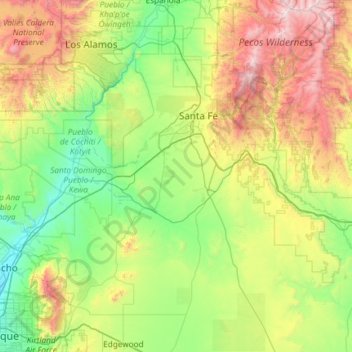
Name: Topografische Karte Santa Fe County, Höhe, Relief.
Ort: Santa Fe County, Nieuw-Mexico, VS (35.04056 -106.24922 36.00449 -105.71456)
Durchschnittliche Höhe: 2.177 m
Minimale Höhe: 1.527 m
Maximale Höhe: 3.974 m
Andere topografische Karten
Klicken Sie auf eine Karte, um ihre Topografie, ihre Höhe und ihr Relief anzuzeigen.
Bernalillo County
Bernalillo County, Nieuw-Mexico, VS
Durchschnittliche Höhe: 1.808 m
Puesta Del Sol
VS > Nieuw-Mexico > Puesta Del Sol
Puesta Del Sol, Sandoval County, Nieuw-Mexico, 87043, VS
Durchschnittliche Höhe: 1.807 m
White Peak
White Peak, Colfax County, Nieuw-Mexico, VS
Durchschnittliche Höhe: 2.574 m
Chaco Culture National Historical Park
Chaco Culture National Historical Park, Chaco Loop Road, San Juan County, Nieuw-Mexico, VS
Durchschnittliche Höhe: 1.919 m
Santa Fe
VS > Nieuw-Mexico > Santa Fe
Santa Fe, Santa Fe County, Nieuw-Mexico, VS
Durchschnittliche Höhe: 2.222 m
Los Alamos
VS > Nieuw-Mexico > Los Alamos
Los Alamos, Los Alamos County, Nieuw-Mexico, VS
Durchschnittliche Höhe: 2.231 m
Los Alamos County
Los Alamos County, Nieuw-Mexico, VS
Durchschnittliche Höhe: 2.315 m