
Topografische Karte Crab Island
Klicken Sie auf die Karte, um die Höhe anzuzeigen.
Über diese Karte
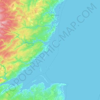
Name: Topografische Karte Crab Island, Höhe, Relief.
Ort: Crab Island, Northumberland County, New Brunswick, Canada (46.97082 -65.27155 47.61082 -64.63155)
Durchschnittliche Höhe: 21 m
Minimale Höhe: -4 m
Maximale Höhe: 162 m
Andere topografische Karten
Klicken Sie auf eine Karte, um ihre Topografie, ihre Höhe und ihr Relief anzuzeigen.
Nashwaak River
Canada > New Brunswick > Saint Marys Parish > Richibucto Road
Durchschnittliche Höhe: 134 m
Lamèque Island
Canada > New Brunswick > Gloucester County > île-de-Lamèque
Durchschnittliche Höhe: 3 m
Fredericton
Canada > New Brunswick > Kingsclear Parish > Fredericton
At an altitude of about 17 m (56 ft) above sea level, Fredericton is nestled in the Pennsylvanian Basin. It differs markedly from the geologically older parts of the province. There are prominently two distinct areas in the region that are divided around the area of Wilsey Road, in the east end of the city. In…
Durchschnittliche Höhe: 72 m
City of Fredericton
At an altitude of about 17 m (56 ft) above sea level, Fredericton is nestled in the Pennsylvanian Basin. It differs markedly from the geologically older parts of the province. There are prominently two distinct areas in the region that are divided around the area of Wilsey Road, in the east end of the city. In…
Durchschnittliche Höhe: 71 m
Grand Manan Island
Canada > New Brunswick > Village of Grand Manan > Grand Manan Parish
Durchschnittliche Höhe: 17 m
Fundy National Park of Canada
Canada > New Brunswick > Fundy Albert > Alma Parish
According to the Commission for Environmental Cooperation, the park is located in the Level III- Eastern Temperate Forests (Maine-New Brunswick Plains and Hills) ecoregion. According to the Ecological Framework of Canada, the park is situated in two distinct ecoregions. The southern section of the park falls…
Durchschnittliche Höhe: 230 m
Baie-Sainte-Anne
Canada > New Brunswick > Kent Rural District > Hardwicke Parish
Durchschnittliche Höhe: 13 m
Edmundston
Canada > New Brunswick > Edmundston
Edmundston has a downhill skiing facility in the city at Mont Farlagne. This facility has 3 lifts, a t-bar, a double chair, and a quad chair. It has 14 trails and an elevation of 690 feet. Snowmaking is available. Five trails are lit for night skiing.
Durchschnittliche Höhe: 256 m
Fredericton
Canada > New Brunswick > City of Fredericton
At an altitude of about 17 m (56 ft) above sea level, Fredericton is nestled in the Pennsylvanian Basin. It differs markedly from the geologically older parts of the province. There are prominently two distinct areas in the region that are divided around the area of Wilsey Road, in the east end of the city. In…
Durchschnittliche Höhe: 69 m
Saint-Quentin
Canada > New Brunswick > Saint Quentin Parish
Saint-Quentin is in the Restigouche region of the Appalachian Mountains, 50 kilometres west of Mount Carleton, the province's highest elevation.
Durchschnittliche Höhe: 284 m
Black Point
Canada > New Brunswick > Restigouche Rural District > Durham Parish
Durchschnittliche Höhe: 29 m
Canterbury Parish
Canada > New Brunswick > Municipality of Lakeland Ridges
Durchschnittliche Höhe: 173 m