
Spenden
Topografische Karte Tirur
Klicken Sie auf die Karte, um die Höhe anzuzeigen.
Spenden
Tirur
Tirur is a Town and municipality in Malappuram district in the Indian state of Kerala spread over an area of 62.34 square kilometres (24.07 sq mi). It is one of the business centers of Malappuram district and is situated 26 kilometres (16 mi) west of Malappuram and 52.5 kilometres (32.6 mi) south of Kozhikode, on the Shoranur–Mangalore section of the Mangalore–Chennai railway line. Tirur is also a major regional trading centre for fish and betel leaf and has an average elevation of 2 metres (6 ft 7 in).
Spenden
Über diese Karte
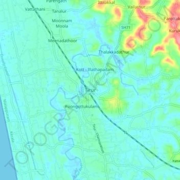
Name: Topografische Karte Tirur, Höhe, Relief.
Ort: Tirur, Malappuram, Kerala, 676101, India (10.87668 75.88399 10.95668 75.96399)
Durchschnittliche Höhe: 15 m
Minimale Höhe: -2 m
Maximale Höhe: 88 m
Spenden
Andere topografische Karten
Klicken Sie auf eine Karte, um ihre Topografie, ihre Höhe und ihr Relief anzuzeigen.