
Topografische Karte Kent
Klicken Sie auf die Karte, um die Höhe anzuzeigen.
Kent
Kent was also the location of the largest number of art schools in the country during the nineteenth century, estimated by the art historian David Haste, to approach two hundred. This is believed to be the result of Kent being a front line county during the Napoleonic Wars. At this time, before the invention of photography, draughtsmen were used to draw maps and topographical representations of the fields of battle, and after the wars ended many of these settled permanently in the county in which they had been based. Once the idea of art schools had been established, even in small towns in Kent, the tradition continued, although most of the schools were very small one man operations, each teaching a small number of daughters of the upper classes how to draw and make watercolour paintings. Nonetheless, some of these small art schools developed into much larger organisations, including Canterbury College of Art, founded by Thomas Sidney Cooper in 1868, which is today the University for the Creative Arts.
Über diese Karte
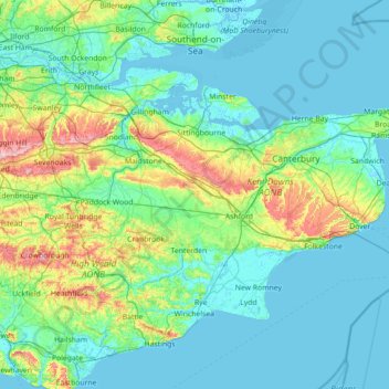
Name: Topografische Karte Kent, Höhe, Relief.
Ort: Kent, South East, England, United Kingdom (50.91048 0.03352 51.48227 1.45177)
Durchschnittliche Höhe: 37 m
Minimale Höhe: -3 m
Maximale Höhe: 263 m
Andere topografische Karten
Klicken Sie auf eine Karte, um ihre Topografie, ihre Höhe und ihr Relief anzuzeigen.
Gateshead
United Kingdom > England > Tyne and Wear > Gateshead
One of the most distinguishing features of Gateshead is its topography. The land rises 230 feet (70 m) from Gateshead Quays to the town centre and continues rising to a height of 525 feet (160 m) at Queen Elizabeth Hospital in Sheriff Hill. This is in contrast to the flat and low lying Team Valley located on…
Durchschnittliche Höhe: 62 m
Cambridge
United Kingdom > England > Cambridge
The city, like most of the UK, has a maritime climate highly influenced by the Gulf Stream. Located in the driest region of Britain, Cambridge's rainfall averages around 570 mm (22.44 in) per year, around half the national average, with some years occasionally falling into the semi-arid (under 500 mm (19.69…
Durchschnittliche Höhe: 18 m
Putney
Putney Heath is around 400 acres (160 hectares) less the nascent A3 road in size and rises to 45 metres (148 ft) above sea level. Because of its elevation, from 1796 to 1816 Putney Heath hosted a station in the shutter telegraph chain, which connected the Admiralty in London to its naval ships in Portsmouth.…
Durchschnittliche Höhe: 18 m
Darwen
United Kingdom > England > Darwen
Much of the town was built between about 1850 and 1900; placenames, date stones in terraces, and the vernacular architecture of cellars, local stone, locally-made brick, pipework and tiles and leaded glass, the last now mostly gone, reflect this. It was one of the first places in the world to have steam trams.…
Durchschnittliche Höhe: 241 m
Bradford
Bradford is located at 53°45′00″N 01°50′00″W / 53.75000°N 1.83333°W / 53.75000; -1.83333 (53.7500, -1.8333)1. Topographically, it is located in the eastern moorland region of the South Pennines.
Durchschnittliche Höhe: 167 m
Royston
Royston lies on the Barnsley Canal, and on the intersection of the B6132 and B6428 roads, due north of Monk Bretton at an elevation of around 246 feet (75 m) above sea level. The Trans Pennine Trail runs through Royston along the canal bank. The parish is part of the diocese of Leeds.
Durchschnittliche Höhe: 74 m
City of London
United Kingdom > England > City of London > City of London
The elevation of the City ranges from sea level at the Thames to 21.6 metres (71 ft) at the junction of High Holborn and Chancery Lane. Two small but notable hills are within the historic core, Ludgate Hill to the west and Cornhill to the east. Between them ran the Walbrook, one of the many "lost" rivers or…
Durchschnittliche Höhe: 42 m
Peterborough
United Kingdom > England > Cambridgeshire
The local topography is flat, and in some places, the land lies below sea level, for example in parts of the Fens to the east and to the south of Peterborough. Human settlement in the area began before the Bronze Age, as can be seen at the Flag Fen archaeological site to the east of the current city centre,…
Durchschnittliche Höhe: 17 m
Rawdon Billing
United Kingdom > England > Rawdon
Rawdon Billing, sometimes referred to as Billing Hill, is a tree-topped hill situated in Rawdon, West Yorkshire, England. Reaching an elevation of 231 metres (758 ft), it is a significant landmark in the Aireborough area.
Durchschnittliche Höhe: 170 m
Leeds
Lying in the eastern foothills of the Pennines, there is a significant variation in elevation within the city's built-up area. The district ranges from 1,115 feet (340 m) in the far west on the slopes of Ilkley Moor to about 33 feet (10 m) where the rivers Aire and Wharfe cross the eastern boundary. Land rises…
Durchschnittliche Höhe: 94 m
Halifax
United Kingdom > England > Calderdale
Topographically, Halifax is located in the south-eastern corner of the moorland region called the South Pennines. Halifax is situated about 4 miles (6 km) from the M62 motorway, close to Bradford and Huddersfield. The A641 road links the town with Brighouse, Bradford and Huddersfield. The Hebble Brook joins…
Durchschnittliche Höhe: 195 m
Reading
United Kingdom > England > Reading
Mary Russell Mitford lived in Reading for a number of years and then spent the rest of her life just outside the town at Three Mile Cross and Swallowfield. The fictional Belford Regis of her eponymous novel, first published in 1835, is largely based on Reading. Described with topographical accuracy, it is…
Durchschnittliche Höhe: 56 m
Swindon
United Kingdom > England > Swindon
Swindon has an oceanic climate (Cfb in the Köppen climate classification), like the vast majority of the British Isles, with cool winters and warm summers. The nearest official weather station is RAF Lyneham, about 10 miles (16 km) west southwest of Swindon town centre. The weather station's elevation is 145…
Durchschnittliche Höhe: 108 m
Hull
United Kingdom > England > Kingston upon Hull
Kingston upon Hull is on the northern bank of the Humber Estuary. The city centre is west of the River Hull and close to the Humber. The city is built upon alluvial and glacial deposits which overlie chalk rocks but the underlying chalk has no influence on the topography. The land within the city is generally…
Durchschnittliche Höhe: 21 m
Lower Shiplake
United Kingdom > England > Oxfordshire > South Oxfordshire
Durchschnittliche Höhe: 56 m
Saltfleetby St Peter
United Kingdom > England > Lincolnshire > East Lindsey
Durchschnittliche Höhe: 3 m
Stanton-in-Peak
United Kingdom > England > Derbyshire > Derbyshire Dales
Durchschnittliche Höhe: 175 m
Wick
United Kingdom > England > West Sussex > Arun > Littlehampton > Lyminster
Durchschnittliche Höhe: 3 m
Great Norwood
United Kingdom > England > Kent > Borough of Swale > Bobbing
Durchschnittliche Höhe: 27 m
Little Ouse
United Kingdom > England > Norfolk > Breckland District > Brettenham
Durchschnittliche Höhe: 23 m
Romney, Hythe and Dymchurch Railway
United Kingdom > England > Kent > Folkestone and Hythe > St. Mary in the Marsh
Durchschnittliche Höhe: 1 m
Amble
United Kingdom > England > Northumberland
Samuel Lewis reported a township population of 247 in 1831. By the seventh edition of his Topographical Dictionary of England, which was published in 1848, this figure had risen to 724. The population was reported as being 1,040 in 1851. The 1871 census recorded a population of 1,233, spread among 233 houses.
Durchschnittliche Höhe: 15 m