
Spenden
Topografische Karte Crestview Manor
Klicken Sie auf die Karte, um die Höhe anzuzeigen.
Spenden
Über diese Karte
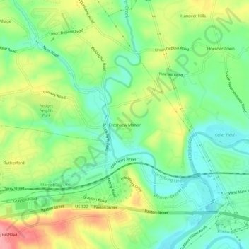
Name: Topografische Karte Crestview Manor, Höhe, Relief.
Durchschnittliche Höhe: 133 m
Minimale Höhe: 90 m
Maximale Höhe: 200 m
Spenden
Andere topografische Karten
Klicken Sie auf eine Karte, um ihre Topografie, ihre Höhe und ihr Relief anzuzeigen.
Spenden
Spenden
Hummelstown
United States > Pennsylvania > Dauphin County
Hummelstown is located in southern Dauphin County at 40°15′55″N 076°42′30″W / 40.26528°N 76.70833°W / 40.26528; -76.70833 (40.265168, −76.710995) at an elevation of 397 feet (121 m) above sea level. According to the United States Census Bureau, the borough has a total area of 1.3 square…
Durchschnittliche Höhe: 117 m
Paxton Creek
United States > Pennsylvania > Dauphin County > Susquehanna Township
Durchschnittliche Höhe: 134 m
Spenden
Colonial Park
United States > Pennsylvania > Dauphin County > Lower Paxton Township > Colonial Park
Durchschnittliche Höhe: 148 m
Linglestown
United States > Pennsylvania > Dauphin County > Lower Paxton Township > Linglestown
The highest elevation is 995 feet (303 m) on the south slope of Blue Mountain, along Blue Mountain Parkway north of the center of town. Pennsylvania Route 39 (Linglestown Road) passes east-to-west through the village, leading east 3.5 miles (5.6 km) to Exit 77 on Interstate 81 and west 5 miles (8 km) to…
Durchschnittliche Höhe: 161 m
Paxtonia
United States > Pennsylvania > Dauphin County > Lower Paxton Township > Paxtonia
Durchschnittliche Höhe: 150 m
Spenden
Blue Mountain
United States > Pennsylvania > Dauphin County > Middle Paxton Township
The ridge of Blue Mountain runs for 150 miles (240 km) through Pennsylvania, reaching an elevation of 2,270 feet (690 m) above sea level just north of the Pennsylvania Turnpike, near the borough of Newburg. Most of the ridgecrest, however, only reaches between 1,400 and 1,700 feet (430 and 520 m) in elevation.…
Durchschnittliche Höhe: 199 m
Spenden
Spenden
Clark Creek
United States > Pennsylvania > Dauphin County > Middle Paxton Township
Durchschnittliche Höhe: 135 m
Spenden
Susquehanna River
United States > Pennsylvania > Dauphin County > Susquehanna Township > Montrose Park
Durchschnittliche Höhe: 114 m
Spenden
Mauntain View Lake
United States > Pennsylvania > Dauphin County > Halifax Township
Durchschnittliche Höhe: 207 m
Hummelstown
United States > Pennsylvania > Dauphin County
Hummelstown is located in southern Dauphin County at 40°15′55″N 076°42′30″W / 40.26528°N 76.70833°W / 40.26528; -76.70833 (40.265168, −76.710995) at an elevation of 397 feet (121 m) above sea level. According to the United States Census Bureau, the borough has a total area of 1.3 square…
Durchschnittliche Höhe: 117 m
Spenden
Linglestown
United States > Pennsylvania > Dauphin County > Linglestown
The highest elevation is 995 feet (303 m) on the south slope of Blue Mountain, along Blue Mountain Parkway north of the center of town. Pennsylvania Route 39 (Linglestown Road) passes east-to-west through the village, leading east 3.5 miles (5.6 km) to Exit 77 on Interstate 81 and west 5 miles (8 km) to…
Durchschnittliche Höhe: 161 m
Spenden