
Topografische Karte Thames Ditton
Klicken Sie auf die Karte, um die Höhe anzuzeigen.
Über diese Karte
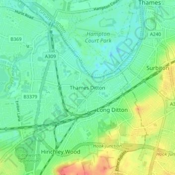
Name: Topografische Karte Thames Ditton, Höhe, Relief.
Durchschnittliche Höhe: 17 m
Minimale Höhe: -2 m
Maximale Höhe: 55 m
Andere topografische Karten
Klicken Sie auf eine Karte, um ihre Topografie, ihre Höhe und ihr Relief anzuzeigen.
Cobham
United Kingdom > England > Surrey > Elmbridge
The River Mole runs through Cobham, with a visitor area and well-surfaced path by the mill in the High Street, dividing the low-rise urban village/town centre from the remaining agricultural parts of Cobham in the west and south. This can flood small, old parts of the village centre in extreme rainfall.…
Durchschnittliche Höhe: 28 m
Esher
United Kingdom > England > Surrey > Elmbridge
Esher is an outlying suburb of London, close to the London–Surrey border; with Esher Commons at its southern end, the town marks one limit of the Greater London Built-Up Area. Esher has a linear commercial high street and is otherwise suburban in density, with varying elevations, few high rise buildings and…
Durchschnittliche Höhe: 21 m