
Topografische Karte Church Road
Interaktive Karte
Klicken Sie auf die Karte, um die Höhe anzuzeigen.
Über diese Karte
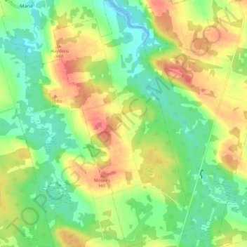
Name: Topografische Karte Church Road, Höhe, Relief.
Ort: Church Road, Kings County, Prince Edward Island, Canada (46.34084 -62.64880 46.40657 -62.59453)
Durchschnittliche Höhe: 28 m
Minimale Höhe: -2 m
Maximale Höhe: 63 m
Andere topografische Karten
Klicken Sie auf eine Karte, um ihre Topografie, ihre Höhe und ihr Relief anzuzeigen.
Brudenell
Canada > Prince Edward Island > Kings County
Brudenell, Town of Three Rivers, Kings County, Prince Edward Island, Canada
Durchschnittliche Höhe: 31 m
Cardigan
Canada > Prince Edward Island > Kings County
Cardigan, Town of Three Rivers, Kings County, Prince Edward Island, Canada
Durchschnittliche Höhe: 27 m
Murray Harbour North
Canada > Prince Edward Island > Kings County > Murray Harbour North
Murray Harbour North, Kings County, Prince Edward Island, Canada
Durchschnittliche Höhe: 13 m
Saint Andrews
Canada > Prince Edward Island > Kings County > Saint Andrews
Saint Andrews, Kings County, Prince Edward Island, Canada
Durchschnittliche Höhe: 12 m
Chepstow
Canada > Prince Edward Island > Kings County > Chepstow
Chepstow, Kings County, Prince Edward Island, Canada
Durchschnittliche Höhe: 8 m
Cardross
Canada > Prince Edward Island > Kings County
Cardross, Kings County, Prince Edward Island, Canada
Durchschnittliche Höhe: 34 m