
Topografische Karte Baltics Corners
Interaktive Karte
Klicken Sie auf die Karte, um die Höhe anzuzeigen.
Über diese Karte
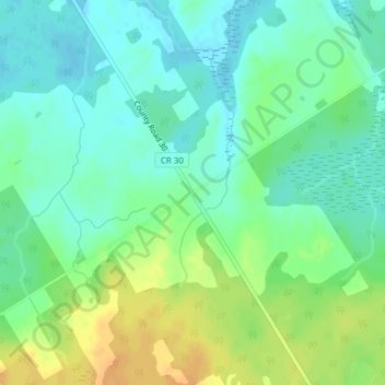
Name: Topografische Karte Baltics Corners, Höhe, Relief.
Durchschnittliche Höhe: 95 m
Minimale Höhe: 83 m
Maximale Höhe: 115 m
Andere topografische Karten
Klicken Sie auf eine Karte, um ihre Topografie, ihre Höhe und ihr Relief anzuzeigen.
Apple Hill
Canada > Ontario > Stormont, Dundas and Glengarry Counties > North Glengarry
Apple Hill, North Glengarry, Stormont, Dundas and Glengarry Counties, Eastern Ontario, Ontario, K0C 1B0, Canada
Durchschnittliche Höhe: 90 m
Alexandria
Canada > Ontario > Stormont, Dundas and Glengarry Counties > North Glengarry
Alexandria, North Glengarry, Stormont, Dundas and Glengarry Counties, Eastern Ontario, Ontario, K0C 1A0, Canada
Durchschnittliche Höhe: 84 m