
Topografische Karte Ballycross
Interaktive Karte
Klicken Sie auf die Karte, um die Höhe anzuzeigen.
Über diese Karte
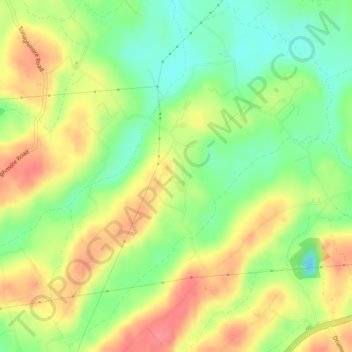
Name: Topografische Karte Ballycross, Höhe, Relief.
Durchschnittliche Höhe: 89 m
Minimale Höhe: 55 m
Maximale Höhe: 124 m
Andere topografische Karten
Klicken Sie auf eine Karte, um ihre Topografie, ihre Höhe und ihr Relief anzuzeigen.
Newry
United Kingdom > Northern Ireland > Newry
Newry, Newry, Mourne and Down District Council, Northern Ireland, United Kingdom
Durchschnittliche Höhe: 119 m
Carlingford Lough
United Kingdom > Northern Ireland > Newry > Greencastle
Carlingford Lough, Newry, Northern Ireland, A91 A0V1, United Kingdom
Durchschnittliche Höhe: 0 m
Newry
United Kingdom > Northern Ireland > Newry
Newry, County Down, Northern Ireland, BT34 1DG, United Kingdom
Durchschnittliche Höhe: 129 m
Mourne Mountains West
United Kingdom > Northern Ireland > Newry
Mourne Mountains West, Newry, County Down, Northern Ireland, United Kingdom
Durchschnittliche Höhe: 272 m