
Spenden
Topografische Karte Lesko
Klicken Sie auf die Karte, um die Höhe anzuzeigen.
Spenden
Lesko
Lesko [ˈlɛskɔ] (or Lisko until 1926; Ukrainian: Лісько, romanized: Lisko; Latin: Lescow, alias Olesco Lescovium; Yiddish: לינסק, romanized: Linsk) is a town in south-eastern Poland with a population of 5,755 (02.06.2009) situated in the Bieszczady mountains. It is located in the heartland of the Doły (Pits), and its average altitude is 390 metres (1,280 feet) above sea level, although there are some hills located within the confines of the city. Since 2002 it has been the capital of Lesko County.
Spenden
Über diese Karte
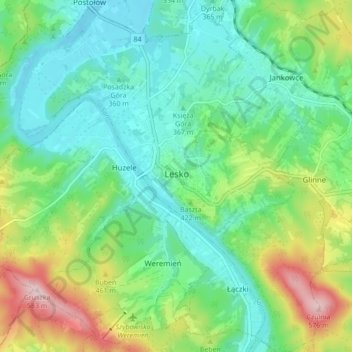
Name: Topografische Karte Lesko, Höhe, Relief.
Durchschnittliche Höhe: 387 m
Minimale Höhe: 306 m
Maximale Höhe: 579 m
Spenden
Andere topografische Karten
Klicken Sie auf eine Karte, um ihre Topografie, ihre Höhe und ihr Relief anzuzeigen.