
Topografische Karte Genoa
Interaktive Karte
Klicken Sie auf die Karte, um die Höhe anzuzeigen.
Über diese Karte
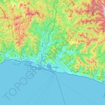
Name: Topografische Karte Genoa, Höhe, Relief.
Ort: Genoa, Liguria, Italy (44.37847 8.66574 44.51984 9.09558)
Durchschnittliche Höhe: 333 m
Minimale Höhe: -4 m
Maximale Höhe: 1.525 m
The city of Genoa covers an area of 243 square kilometres (94 sq mi) between the Ligurian Sea and the Apennine Mountains. The city stretches along the coast for about 30 kilometres (19 mi) from the neighbourhood of Voltri to Nervi, and for 10 kilometres (6.2 mi) from the coast to the north along the valleys Polcevera and Bisagno. The territory of Genoa is popularly divided into 5 main zones: the centre, the west, the east, the Polcevera and the Bisagno Valley. Although much of the city centre is located at a low elevation, the territory surrounding it is mountainous with undeveloped land usually being in steep terrain.
Andere topografische Karten
Klicken Sie auf eine Karte, um ihre Topografie, ihre Höhe und ihr Relief anzuzeigen.
Campomorone
Campomorone, Genoa, Liguria, 16014, Italy
Durchschnittliche Höhe: 439 m
Montelungo
Italy > Liguria > Genoa > Genoa
Montelungo, Media Val Bisagno, Genoa, Liguria, 16165, Italy
Durchschnittliche Höhe: 282 m
Spianata dell'Acquasola
Italy > Liguria > Genoa > Genoa
Spianata dell'Acquasola, San Vincenzo, Centro Est, Genoa, Liguria, Italy
Durchschnittliche Höhe: 43 m
Mileto
Italy > Liguria > Genoa > Rezzoaglio
Mileto, Rezzoaglio, Genoa, Liguria, 16048, Italy
Durchschnittliche Höhe: 954 m