
Spenden
Topografische Karte Ponteilla
Klicken Sie auf die Karte, um die Höhe anzuzeigen.
Spenden
Über diese Karte
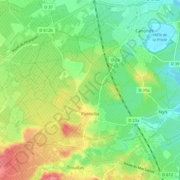
Name: Topografische Karte Ponteilla, Höhe, Relief.
Durchschnittliche Höhe: 84 m
Minimale Höhe: 52 m
Maximale Höhe: 135 m
Spenden
Andere topografische Karten
Klicken Sie auf eine Karte, um ihre Topografie, ihre Höhe und ihr Relief anzuzeigen.
Pic de Finestrelles
France > Occitania > Pyrénées-Orientales > Eyne
Pic de Finestrelles is a mountain located in the Oriental Pyrenees, on the border of France and Spain. It has an altitude of 2,826 metres (9,272 ft) above sea level.
Durchschnittliche Höhe: 2.502 m
Pic de Finestrelles
France > Occitania > Pyrénées-Orientales > Eyne
Pic de Finestrelles is a mountain located in the Oriental Pyrenees, on the border of France and Spain. It has an altitude of 2,826 metres (9,272 ft) above sea level.
Durchschnittliche Höhe: 2.502 m
Spenden
Odeillo
France > Occitania > Pyrénées-Orientales > Font-Romeu-Odeillo-Via
Durchschnittliche Höhe: 1.631 m
Spenden
Riuros
France > Occitania > Pyrénées-Orientales > Saint-Laurent-de-Cerdans
Durchschnittliche Höhe: 759 m
La Ville
France > Occitania > Pyrénées-Orientales > Saint-Laurent-de-la-Salanque
Durchschnittliche Höhe: 4 m
Spenden
Station de Puyvalador
France > Occitania > Pyrénées-Orientales > Puyvalador
Durchschnittliche Höhe: 1.768 m
Spenden