Geolokalisieren
👉 Easily get elevation data in JSON, GeoTIFF and KML formats using Elevation API
Vielen Dank für die Unterstützung dieser Website ❤️
Spenden

Topografische Karte Lake Cachuma

Klicken Sie auf die Karte, um die Höhe anzuzeigen.

👉 Easily get elevation data in JSON, GeoTIFF and KML formats using Elevation API
Vielen Dank für die Unterstützung dieser Website ❤️
Spenden

Über diese Karte

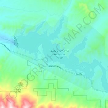
Name: Topografische Karte Lake Cachuma, Höhe, Relief.

Ort: Lake Cachuma, Santa Barbara County, California, United States (34.54761 -119.98285 34.60632 -119.88144)

Durchschnittliche Höhe: 347 m

Minimale Höhe: 169 m

Maximale Höhe: 1.087 m

👉 Easily get elevation data in JSON, GeoTIFF and KML formats using Elevation API
Vielen Dank für die Unterstützung dieser Website ❤️
Spenden

Andere topografische Karten

Klicken Sie auf eine Karte, um ihre Topografie, ihre Höhe und ihr Relief anzuzeigen.

Lompoc

United States > California > Santa Barbara County

Durchschnittliche Höhe: 57 m

Montecito

United States > California > Santa Barbara County

Durchschnittliche Höhe: 213 m

Los Olivos

United States > California > Santa Barbara County

Durchschnittliche Höhe: 277 m

Orcutt

United States > California > Santa Barbara County

Durchschnittliche Höhe: 155 m

Vielen Dank für die Unterstützung dieser Website ❤️
Spenden

Twitchell Dam

United States > California > Santa Barbara County

Durchschnittliche Höhe: 258 m

Montecito Peak

United States > California > Santa Barbara County

Durchschnittliche Höhe: 709 m

Promontory

United States > California > Santa Barbara County

Durchschnittliche Höhe: 25 m

Vielen Dank für die Unterstützung dieser Website ❤️
Spenden

Montecito

United States > California > Santa Barbara County

Durchschnittliche Höhe: 213 m

7 falls

United States > California > Santa Barbara County

Durchschnittliche Höhe: 583 m

Honda

United States > California > Santa Barbara County

Durchschnittliche Höhe: 55 m

Vielen Dank für die Unterstützung dieser Website ❤️
Spenden

Naples

United States > California > Santa Barbara County

Durchschnittliche Höhe: 25 m

Los Alamos

United States > California > Santa Barbara County

Durchschnittliche Höhe: 235 m

Vielen Dank für die Unterstützung dieser Website ❤️
Spenden

Sutil Island

United States > California > Santa Barbara County

Durchschnittliche Höhe: 14 m

Vielen Dank für die Unterstützung dieser Website ❤️
Spenden

Buellton

United States > California > Santa Barbara County

Durchschnittliche Höhe: 127 m

Lompoc

United States > California > Santa Barbara County

Durchschnittliche Höhe: 57 m

Solvang

United States > California > Santa Barbara County

Durchschnittliche Höhe: 194 m

Orcutt

United States > California > Santa Barbara County

Durchschnittliche Höhe: 155 m

Vielen Dank für die Unterstützung dieser Website ❤️
Spenden