Geolokalisieren
👉 Easily get elevation data in JSON, GeoTIFF and KML formats using Elevation API
Vielen Dank für die Unterstützung dieser Website ❤️
Spenden

Topografische Karte Chester

Klicken Sie auf die Karte, um die Höhe anzuzeigen.

👉 Easily get elevation data in JSON, GeoTIFF and KML formats using Elevation API
Vielen Dank für die Unterstützung dieser Website ❤️
Spenden

Über diese Karte

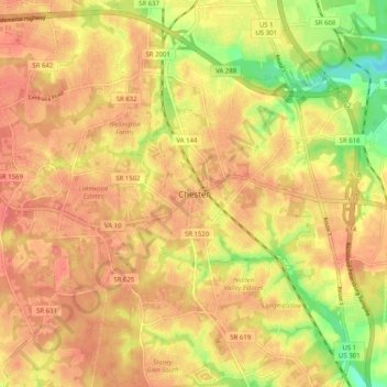
Name: Topografische Karte Chester, Höhe, Relief.

Ort: Chester, Chesterfield County, Virginia, 23831, United States (37.31622 -77.48606 37.39622 -77.40606)

Durchschnittliche Höhe: 46 m

Minimale Höhe: 2 m

Maximale Höhe: 69 m

👉 Easily get elevation data in JSON, GeoTIFF and KML formats using Elevation API
Vielen Dank für die Unterstützung dieser Website ❤️
Spenden

Andere topografische Karten

Klicken Sie auf eine Karte, um ihre Topografie, ihre Höhe und ihr Relief anzuzeigen.

Bon Air

United States > Virginia > Chesterfield County > Bon Air

In the 19th century, it was believed that the higher elevation and distance from the urban area of Richmond provided a more healthful atmosphere, particularly in the hot summer months in central Virginia. With its nearby location and greater elevation, Bon Air offered these features nearby, and was founded as…

Durchschnittliche Höhe: 88 m

Woodlake

United States > Virginia > Chesterfield County > Woodlake

Durchschnittliche Höhe: 66 m

Midlothian

United States > Virginia > Chesterfield County > Midlothian

Durchschnittliche Höhe: 92 m

Finger Lakes

United States > Virginia > Chesterfield County

Durchschnittliche Höhe: 97 m

Vielen Dank für die Unterstützung dieser Website ❤️
Spenden

Finger Lakes

United States > Virginia > Chesterfield County

Durchschnittliche Höhe: 97 m

Midlothian

United States > Virginia > Chesterfield County > Midlothian

Durchschnittliche Höhe: 92 m

Chester

United States > Virginia > Chesterfield County > Chester

Durchschnittliche Höhe: 44 m

Chester

United States > Virginia > Chesterfield County > Chester

Durchschnittliche Höhe: 43 m

Vielen Dank für die Unterstützung dieser Website ❤️
Spenden

Chester

United States > Virginia > Chesterfield County

Durchschnittliche Höhe: 45 m

Finger Lakes

United States > Virginia > Chesterfield County

Durchschnittliche Höhe: 97 m

Bon Air

United States > Virginia > Chesterfield County > Bon Air

In the 19th century, it was believed that the higher elevation and distance from the urban area of Richmond provided a more healthful atmosphere, particularly in the hot summer months in central Virginia. With its nearby location and greater elevation, Bon Air offered these features nearby, and was founded as…

Durchschnittliche Höhe: 87 m