
Vielen Dank für die Unterstützung dieser Website ❤️
Spenden
Spenden
Topografische Karte Chartres Cathedral
Klicken Sie auf die Karte, um die Höhe anzuzeigen.
Vielen Dank für die Unterstützung dieser Website ❤️
Spenden
Spenden
Chartres Cathedral
The elevation of the nave, showing the gallery on the ground level; the narrow triforium; and, on top, the windows of the clerestory
Vielen Dank für die Unterstützung dieser Website ❤️
Spenden
Spenden
Über diese Karte
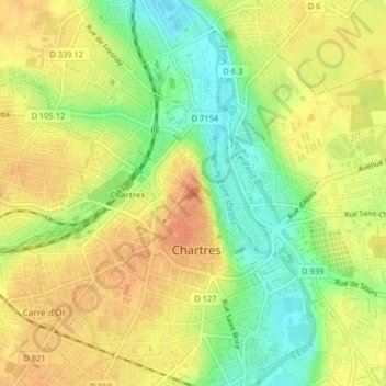
Name: Topografische Karte Chartres Cathedral, Höhe, Relief.
Durchschnittliche Höhe: 148 m
Minimale Höhe: 123 m
Maximale Höhe: 165 m
Vielen Dank für die Unterstützung dieser Website ❤️
Spenden
Spenden