
Spenden
Topografische Karte Sweet Valley
Klicken Sie auf die Karte, um die Höhe anzuzeigen.
Spenden
Über diese Karte
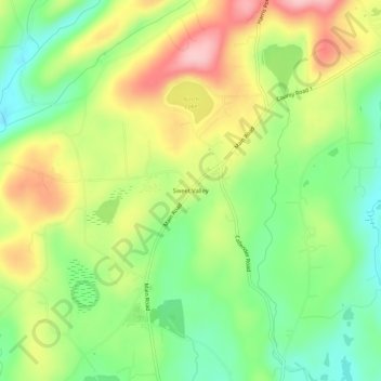
Name: Topografische Karte Sweet Valley, Höhe, Relief.
Durchschnittliche Höhe: 390 m
Minimale Höhe: 314 m
Maximale Höhe: 487 m
Spenden
Andere topografische Karten
Klicken Sie auf eine Karte, um ihre Topografie, ihre Höhe und ihr Relief anzuzeigen.
Pittston Township
United States > Pennsylvania > Luzerne County
According to the United States Census Bureau, the township has a total area of 13.79 square miles (35.71 km2), of which 13.77 square miles (35.66 km2) is land and 0.02 square miles (0.05 km2), or 0.15%, is water. It is the second largest community by area in Greater Pittston. The township is served by the…
Durchschnittliche Höhe: 372 m
Lake Leigh Dam (defunct)
United States > Pennsylvania > Luzerne County > Fairmount Township
Durchschnittliche Höhe: 672 m
Spenden
Spenden
Penn Lake
United States > Pennsylvania > Luzerne County > Penn Lake Park
Durchschnittliche Höhe: 421 m
Spenden
Natural Lands Trust Bear Creek Preserve - Dry Land Hill Parcel
United States > Pennsylvania > Luzerne County > Shades Glen
Durchschnittliche Höhe: 507 m
Spenden
Spenden
Ricketts Glen State Park
United States > Pennsylvania > Luzerne County > Fairmount Township
The state's original plans for the new park included building an inn, an 18-hole golf course and country club, and a winter sports complex for skiing, ice boating, and tobogganing, as well as a beach with bathing facilities, cabins, and a tent camping area. Only the last three were actually built, all south of…
Durchschnittliche Höhe: 588 m
Scouton Lee Park
United States > Pennsylvania > Luzerne County > Wilkes-Barre > Parsons
Durchschnittliche Höhe: 192 m
Huntington Creek
United States > Pennsylvania > Luzerne County > Pleasant Valley
Durchschnittliche Höhe: 308 m
Spenden