
Spenden
Topografische Karte Northampton
Klicken Sie auf die Karte, um die Höhe anzuzeigen.
Spenden
Northampton
According to the U.S. Census Bureau, the borough has a total area of 2.7 square miles (7.0 km2); 2.6 square miles (6.7 km2) is land and 0.1 square miles (0.26 km2) (3.70%), water. Northampton's elevation is 370 feet (110 m) above sea level.
Spenden
Über diese Karte
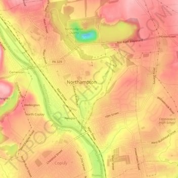
Name: Topografische Karte Northampton, Höhe, Relief.
Ort: Northampton, Northampton County, Pennsylvania, United States (40.66687 -75.51586 40.70441 -75.47217)
Durchschnittliche Höhe: 113 m
Minimale Höhe: 11 m
Maximale Höhe: 159 m
Spenden
Andere topografische Karten
Klicken Sie auf eine Karte, um ihre Topografie, ihre Höhe und ihr Relief anzuzeigen.
Weiders Crossing
United States > Pennsylvania > Northampton County > Lehigh Township
Durchschnittliche Höhe: 218 m
Pennsville
United States > Pennsylvania > Northampton County > Lehigh Township
Durchschnittliche Höhe: 191 m
Raubsville
United States > Pennsylvania > Northampton County > Williams Township
Durchschnittliche Höhe: 102 m
Spenden
Slateford
United States > Pennsylvania > Northampton County > Upper Mount Bethel Township
Durchschnittliche Höhe: 192 m
Kesslersville
United States > Pennsylvania > Northampton County > Plainfield Township
Durchschnittliche Höhe: 177 m
Spenden
Stouts
United States > Pennsylvania > Northampton County > Williams Township > Stouts
Durchschnittliche Höhe: 165 m
Green Pond
United States > Pennsylvania > Northampton County > Bethlehem Township
Durchschnittliche Höhe: 124 m
Browntown
United States > Pennsylvania > Northampton County > Glendon > Browntown
Durchschnittliche Höhe: 114 m
Spenden
Butztown
United States > Pennsylvania > Northampton County > Bethlehem Township
Durchschnittliche Höhe: 110 m