
Topografische Karte Ormiston
Interaktive Karte
Klicken Sie auf die Karte, um die Höhe anzuzeigen.
Über diese Karte
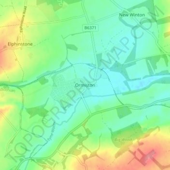
Name: Topografische Karte Ormiston, Höhe, Relief.
Ort: Ormiston, East Lothian, Scotland, EH35 5HN, United Kingdom (55.89285 -2.95984 55.93285 -2.91984)
Durchschnittliche Höhe: 102 m
Minimale Höhe: 75 m
Maximale Höhe: 159 m
Ormiston is a village in East Lothian, Scotland, near Tranent, Humbie, Pencaitland and Cranston, located on the north bank of the River Tyne at an elevation of about 276 feet (84 m).